Boutilimit
Appearance
(Redirected from Boutilimitt)
Boutilimit | |
|---|---|
Commune and town | |
 | |
| Coordinates: 17°31′N 14°46′W / 17.517°N 14.767°W | |
| Country | |
| Region | Trarza |
| Area | |
• Commune and town | 709.2 km2 (273.8 sq mi) |
| Population | |
• Commune and town | 26,926 |
| • Density | 38/km2 (98/sq mi) |
| • Urban | 15,536 |
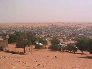
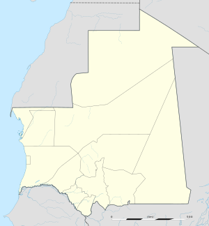
Boutilimit (Arabic: بوتلميت) lies 164 km southeast of Mauritania's capital of Nouakchott.
The estimated population in 2013 was 26,926.[1]
The town is also well known in the region for its production of handicraft items, particularly rugs made from camel or goat hair, as well as silver crafts.
Notable people
[edit]Notable people from the town include Moktar Ould Daddah, the nation's first President following independence from France, the writers Aïchetou Mint Ahmedou and Moussa Ould Ebnou, the deputy L’Malouma Said, and the journalist Naha Mint Seyyidi.[2]
Mohammad Al-Hasan Al-Dido was born in Boutilimit, he is a Mauritanian Muslim scholar, author, writer, and poet.[3]

Climate
[edit]| Climate data for Boutilimit | |||||||||||||
|---|---|---|---|---|---|---|---|---|---|---|---|---|---|
| Month | Jan | Feb | Mar | Apr | May | Jun | Jul | Aug | Sep | Oct | Nov | Dec | Year |
| Mean daily maximum °C (°F) | 29.9 (85.8) |
32.7 (90.9) |
35.7 (96.3) |
37.8 (100.0) |
40.6 (105.1) |
40.7 (105.3) |
37.5 (99.5) |
35.9 (96.6) |
36.6 (97.9) |
37.5 (99.5) |
35.1 (95.2) |
30.1 (86.2) |
35.8 (96.5) |
| Daily mean °C (°F) | 21.8 (71.2) |
25.4 (77.7) |
27.7 (81.9) |
29.7 (85.5) |
33.0 (91.4) |
33.1 (91.6) |
29.9 (85.8) |
30.5 (86.9) |
31.0 (87.8) |
32.2 (90.0) |
26.9 (80.4) |
23.0 (73.4) |
28.7 (83.6) |
| Mean daily minimum °C (°F) | 15.4 (59.7) |
17.0 (62.6) |
18.7 (65.7) |
20.3 (68.5) |
22.8 (73.0) |
24.0 (75.2) |
23.9 (75.0) |
24.0 (75.2) |
24.3 (75.7) |
23.4 (74.1) |
20.4 (68.7) |
16.0 (60.8) |
20.9 (69.5) |
| Average rainfall mm (inches) | 1 (0.0) |
2 (0.1) |
1 (0.0) |
1 (0.0) |
3 (0.1) |
5 (0.2) |
32 (1.3) |
64 (2.5) |
46 (1.8) |
15 (0.6) |
3 (0.1) |
2 (0.1) |
173 (6.8) |
| Average relative humidity (%) | 29 | 28 | 28 | 30 | 34 | 46 | 64 | 70 | 75 | 45 | 34 | 33 | 43 |
| Mean daily sunshine hours | 8.7 | 9.2 | 10.0 | 10.8 | 10.5 | 10.0 | 9.8 | 9.0 | 8.8 | 8.6 | 8.9 | 8.1 | 9.4 |
| Source: Arab Meteorology Book[4] | |||||||||||||
References
[edit]Wikimedia Commons has media related to Boutilimit.
- ^ "Boutilimit (Agricultural Urban Commune, Mauritania) - Population Statistics, Charts, Map and Location". www.citypopulation.de. Retrieved 2024-02-15.
- ^ Hasan, Rabiul. "Global Ties Arizona honors L' Malouma Said's life and work". Northeast Valley News. Archived from the original on 2019-03-27. Retrieved 2019-03-13.
- ^ "التفريغ النصي - اغتنام الحياة - للشيخ محمد الحسن الددو الشنقيطي". Islamweb إسلام ويب (in Arabic). Retrieved 2022-12-19.
- ^ "Appendix I: Meteorological Data" (PDF). Springer. Archived from the original (PDF) on March 4, 2016. Retrieved 14 October 2024.
17°31′N 14°46′W / 17.517°N 14.767°W

