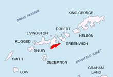
Botev Peak, Livingston Island


Botev Peak (Bulgarian: Ботев връх, romanized: Botev vrah, IPA: [ˈbɔtɛv ˈvrɤx]) is a peak rising to about 370 m in the southern extremity of the Veleka Ridge of Tangra Mountains, eastern Livingston Island in the South Shetland Islands, Antarctica overlooking Tarnovo Ice Piedmont to the east-northeast, Botev Point to the south, Barnard Point to the west and Arkutino Beach to the northwest. The feature takes its name from the adjacent Botev Point.
Location
[edit]The peak is located at 62°45′19.8″S 60°18′31″W / 62.755500°S 60.30861°W which is 1.48 km south of Veleka Peak, 740 m south of Dobrich Knoll and 4.05 km west-southwest of Yambol Peak. The peak was mapped by Bulgaria in 2005 and 2009 and is registered in the SCAR Composite Antarctic Gazetteer.
Maps
[edit]- L.L. Ivanov et al. Antarctica: Livingston Island and Greenwich Island, South Shetland Islands. Scale 1:100000 topographic map. Sofia: Antarctic Place-names Commission of Bulgaria, 2005.
- L.L. Ivanov. Antarctica: Livingston Island and Greenwich, Robert, Snow and Smith Islands. Scale 1:120000 topographic map. Troyan: Manfred Wörner Foundation, 2009. ISBN 978-954-92032-6-4
References
[edit]- Botev Peak. SCAR Composite Gazetteer of Antarctica.
- Bulgarian Antarctic Gazetteer. Antarctic Place-names Commission. (details in Bulgarian, basic data in English)
External links
[edit]- Botev Peak. Copernix satellite image
This article includes information from the Antarctic Place-names Commission of Bulgaria which is used with permission.
