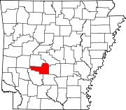
Bonnerdale, Arkansas
Appearance
Bonnerdale, Arkansas | |
|---|---|
| Coordinates: 34°23′05″N 93°22′55″W / 34.38472°N 93.38194°W | |
| Country | United States |
| State | Arkansas |
| County | Hot Spring |
| Elevation | 653 ft (199 m) |
| Time zone | UTC-6 (Central (CST)) |
| • Summer (DST) | UTC-5 (CDT) |
| ZIP code | 71933 |
| Area code | 870 |
| GNIS feature ID | 70762[1] |
Bonnerdale is an unincorporated community in Hot Spring County, Arkansas, United States. Bonnerdale is located on U.S. Route 70 in far western Hot Spring County, 10.5 miles (16.9 km) east-northeast of Glenwood.[2] Bonnerdale has a post office with ZIP code 71933.[3]
Education
[edit]Public education for elementary and secondary school students is provided by the Centerpoint School District,[4][5] which leads to graduation from Centerpoint High School.
The area also includes Lake Hamilton Public Schools, which leads to graduation from Lake Hamilton High School.[citation needed][citation needed]
References
[edit]- ^ a b U.S. Geological Survey Geographic Names Information System: Bonnerdale, Arkansas
- ^ Hot Spring County, Arkansas General Highway Map (PDF) (Map). Arkansas State Highway and Transportation Department. 2007. Archived from the original (PDF) on September 22, 2010. Retrieved May 11, 2011.
- ^ ZIP Code Lookup Archived September 14, 2012, at the Wayback Machine
- ^ "SCHOOL DISTRICT REFERENCE MAP (2010 CENSUS): Hot Spring County, AR", U.S. Census Bureau. Retrieved March 6, 2021.
- ^ "General Highway Map Hot Spring County, Arkansas" (PDF). Arkansas Department of Transportation. Retrieved March 6, 2021. - See Bonnerdale on the map.


