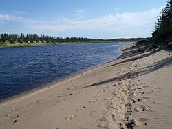
Bolshaya Kheta
Appearance
| Bolshaya Kheta Большая Хета | |
|---|---|
 | |
| Physical characteristics | |
| Source | Lake Yelovoy |
| • coordinates | 67°59′44″N 84°33′42″E / 67.99556°N 84.56167°E |
| • elevation | 150 m (490 ft) |
| Mouth | Yenisey |
• coordinates | 69°33′0″N 84°16′43″E / 69.55000°N 84.27861°E |
• elevation | 1 m (3 ft 3 in) |
| Length | 646 km (401 mi) |
| Basin size | 20,700 km2 (8,000 sq mi) |
| Basin features | |
| Progression | Yenisey→ Kara Sea |
The Bolshaya Kheta (Russian: Большая Хета, "Great Kheta") is a river in Krasnoyarsk Krai, Russia. It is a left tributary of the Yenisey.[1]
Course
[edit]The source of the Bolshaya Kheta is in Lake Yelovoy. It flows roughly northeastwards and joins the Yenisey northwest of Dudinka. The Bolshaya Kheta is 646 kilometres (401 mi) long, and the area of its basin is 20,700 square kilometres (8,000 sq mi).[2]
 |
See also
[edit]References
[edit]- ^ Большая Хета in Great Soviet Encyclopedia in 30 vols. / Ch. ed. A.M. Prokhorov . - 3rd ed. - M, 1969-1978.
- ^ Russian State Water Register - Bolshaya Kheta

