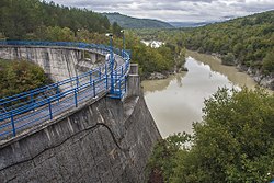
Boljunčica
Appearance
| Boljunčica | |
|---|---|
 | |
 | |
| Location | |
| Country | Croatia |
| Physical characteristics | |
| Mouth | |
• location | Adriatic Sea |
• coordinates | 45°08′00″N 14°10′40″E / 45.1332°N 14.1778°E |
| Length | 33 km (21 mi)[1] |
| Basin size | 230 km2 (89 sq mi)[1] |
Boljunčica is a river in inland Istria, Croatia. It discharges into the Adriatic Sea near Plomin. It is 33 kilometres (21 mi) long and it has a basin with an area of 230 square kilometres (89 sq mi). Its average discharge at the measurement station in Polje Čepić (covering 183 km2 of the basin) is 0.956 m3/s, and it can go completely dry.[1]
Boljunčica rises on the western slopes of the Učka mountain and flows to the south. Near Polje Čepić and Potpićan, it goes underground and emerges near Plomin.
References
[edit]- ^ a b c "Karakteristike značajnijih vodotoka". Vodnogospodarska osnova Hrvatske - Strategija upravljanja vodama (in Croatian). Croatian Parliament. Archived from the original on 2013-10-29. Retrieved 2011-12-18.
Further reading
[edit]- Blažević, Marija (1986). "Istarske rijeke" [Istrian Rivers]. Priroda: popularni časopis hrvatskog prirodoslovnog društva. Vol. 72, no. 8. pp. 228–231. ISSN 0351-0662.

