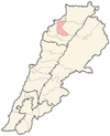
Bnachii
Appearance
Bnachii
بنشعي | |
|---|---|
City | |
| Coordinates: 34°19′58″N 35°53′43″E / 34.33278°N 35.89528°E | |
| Country | |
| Governorate | North Governorate |
| District | Zgharta District |
| Elevation | 450 m (1,480 ft) |
| Time zone | UTC+2 (EET) |
| • Summer (DST) | UTC+3 (EEST) |
| Dialing code | +961 |
Bnashii (also Bnashaai, Bneshaai, Bnechaai, Bnash'i, Arabic: بنشعي) is a village located in the Zgharta District in the North Governorate of Lebanon.[1]
The altitude of the village is 450 meters above sea level. It has a leisure base around its artificial lake.[2]
In 1866, the village was the witness of an important battle between 800 lebanese nationalists led by Youssef Bey Karam and a numerically superior ottoman contingent led by Daoud Pasha.
References
[edit]- ^ Bneshaai, Localiban
- ^ Sfeir, Nagi (2018). "Local economic development via urbanism lever: The case of Lebanon" (PDF). SAUES Journal. 1 (2). doi:10.22034/saues.2018.02.01. Archived from the original (PDF) on 2019-05-09. Retrieved 2020-07-04.


