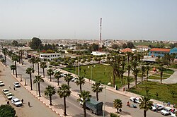
Bir Jdid
Bir Jdid
البئر الجديد al-Bīr-al-Jadīd | |
|---|---|
Town | |
 | |
| Coordinates: 33°22′25″N 8°00′01″W / 33.3737°N 8.0002°W | |
| Country | Morocco |
| Region | Casablanca-Settat |
| Province | El Jadida |
| Population (2004)[1] | |
| • Total | 15,267 |
| Time zone | +1 |
Bir Jdid (Arabic: البير الجديد: "New Well") is a town on the Atlantic coast of Morocco, located between the cities of El Jadida and Casablanca in the region of Doukkala-Abda. It has a population of 15267, according to the 2014 census.
History
[edit]In 1919, the French built two dwellings in the heart of the village, which was called the "Saint Hubert", in relation to a well. The nearby inhabitants of the area used this name to distinguish this modern well from the rest of the old wells and added a new name to the original name of the place. Prior to the protection, the name of the Saint-Hubert was in 1920, where the town became a station between Casablanca and Azemmour, also known as the Fishermen's Forum, which became a resort and a resting place. The name of the new well was added to St. Hubert.
In 1921, a post office was built in the town. In 1926 a local school was established and in 1931 an internal boarding school was established to accommodate the students of the French school (Imam Al-Bukhari high school).
Historically, a secret prison was located in Bir Jdid. Among the people sent to this prison were the family of Mohamed Oufkir, who were subject to torture.[2]
References
[edit]- ^ "World Gazetteer". Archived from the original on February 10, 2013.
- ^ Ph. D Khannous (17 October 2013). African Pasts, Presents, and Futures: Generational Shifts in African Women's Literature, Film, and Internet Discourse. Lexington Books. p. 72. ISBN 978-0-7391-7042-7.

