Bilsborrow
| Bilsborrow | |
|---|---|
| Village | |
 | |
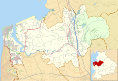
Location within Lancashire | |
| Population | 632 (2011 census) |
| OS grid reference | SD510400 |
| Civil parish | |
| District | |
| Shire county | |
| Region | |
| Country | England |
| Sovereign state | United Kingdom |
| Post town | PRESTON |
| Postcode district | PR3 |
| Dialling code | 01995 |
| Police | Lancashire |
| Fire | Lancashire |
| Ambulance | North West |
| UK Parliament | |
Bilsborrow /ˈbɪlzbərə/ is a village and former civil parish, now in the parish of Myerscough and Bilsborrow, in the Wyre district, in the county of Lancashire, England. The village population at the 2011 census was 632.[1] It is on the A6 road and the Lancaster Canal. It is approximately 1 mile (2 km) east of Myerscough.
Bilsborrow has a primary school, a post office and local shop, and a fish and chip shop, St Hilda's Church of England church and two public houses, the Roebuck and the White Bull, a canalside tavern Owd Nell's Tavern, a Premier Inn hotel, a canalside lodge, a guest house, and a themed thatched hamlet 'village' with restaurant, hotel and tavern.
In 2018, John Cross Church of England Primary School celebrated the 300th anniversary of its founding by John Cross, a local Christian benefactor.
In the former parish is the hamlet of Duncombe. In the 1950s there was a large paper mill at Matshead. The River Brock is crossed by Walmesley Bridge; it is dated 1883 but looks much older.[2]

Civil parish
[edit]Bilsborrow was formerly a township in the parish of Garstang,[3] from 1866 Bilsborrow was a civil parish in its own right,[4] on 1 April 2003 the parish was abolished and merged with Myerscough to form "Myerscough & Bilsborrow".[5] In 2001 the parish had a population of 410.
References
[edit]- ^ UK Census (2011). "Local Area Report – Bilsborrow Built-up area (E34002045)". Nomis. Office for National Statistics. Retrieved 27 May 2019.
- ^ Fleetwood-Hesketh, P. (1955) Murray's Lancashire Architectural Guide. London: John Murray; p. 132
- ^ "History of Bilsborrow, in Wyre and Lancashire". A Vision of Britain through Time. Retrieved 5 August 2023.
- ^ "Relationships and changes Bilsborrow Tn/CP through time". A Vision of Britain through Time. Retrieved 5 August 2023.
- ^ "Lancaster Registration District". UKBMD. Retrieved 5 August 2023.
- Philip's Street Atlas; p. 159
External links
[edit]![]() Media related to Bilsborrow at Wikimedia Commons
Media related to Bilsborrow at Wikimedia Commons


