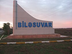
Biləsuvar
Appearance
39°27′30″N 48°32′42″E / 39.45833°N 48.54500°E
Bilasuvar
Biləsuvar | |
|---|---|
 | |
| Coordinates: 39°27′30″N 48°32′42″E / 39.45833°N 48.54500°E | |
| Country | |
| Region | Aran |
| District | Bilasuvar |
| Elevation | 5 m (16 ft) |
| Population (2010) | |
• Total | 20,101 |
| Time zone | UTC+4 (AZT) |
| • Summer (DST) | UTC+5 (AZT) |
| Area code | +994 25 |
| Website | bilesuvar-ih |
Bilasuvar (Azerbaijani: Biləsuvar) is a city in and the capital of the Bilasuvar District of Azerbaijan. The area's considerable agricultural potential depends on irrigation.[1] It is situated near one of the country's four border crossings with Iran.
It has been said that the city's name was called "Pileh-Swar", which meant ‘Elephant-riding Person’ in Persian language, a reference to an early emir.[2] In Azerbaijani the name means ‘Pure Waterfalls‘.[2]
The city is located in the Central Aran region. Biləsuvar was divided into two parts in 1828 with the Turkmanchay Treaty. The similarly-named Iranian city of Bileh Savar is located right across the border.
Gallery
[edit]-
Youth Center
-
School named after hero Mubariz Ibrahimov
References
[edit]- ^ "Azersun". Archived from the original on 19 November 2007. Retrieved 23 November 2007.
- ^ a b Everett-Heath, John (24 October 2019), "Biläsuvar", The Concise Oxford Dictionary of World Place Names, Oxford University Press, doi:10.1093/acref/9780191882913.001.0001/acref-9780191882913-e-846, ISBN 978-0-19-188291-3, retrieved 19 January 2023
External links
[edit]- Biləsuvar at GEOnet Names Server
- World Gazetteer: Azerbaijan[dead link] – World-Gazetteer.com
- Agricultural development news


