Big Sugar Creek State Park
Appearance
| Big Sugar Creek State Park | |
|---|---|
 | |
| Location | McDonald County, Missouri, United States |
| Coordinates | 36°37′17″N 94°17′39″W / 36.62139°N 94.29417°W |
| Area | 2,082.54 acres (8.4277 km2)[1] |
| Established | 1992[2] |
| Visitors | 26,694 (in 2022)[3] |
| Governing body | Missouri Department of Natural Resources |
| Website | Big Sugar Creek State Park |
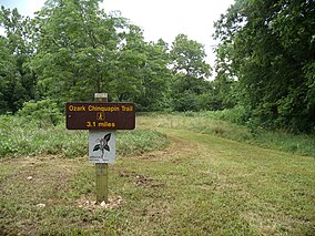
Big Sugar Creek State Park is a public recreation area encompassing more than 2,000 acres (810 ha) in McDonald County in southwest Missouri, United States. The state park was established in 1992 to preserve part of the Elk River water system, which Big Sugar Creek is part of. The park has a three-mile-long (5 km) trail for hiking.[4] A major portion of the park has been designated as the Elk River Breaks Natural Area.[5]
References
[edit]- ^ "Big Sugar Creek State Park: Data Sheet" (PDF). Missouri Department of Natural Resources. November 2017. Retrieved May 2, 2018.
- ^ "State Park Land Acquisition Summary". Missouri State Parks. Retrieved May 2, 2018.
- ^ "Missouri State Park Attendance For January - December, 2022" (PDF). Missouri State Parks. February 3, 2023.
- ^ "Big Sugar Creek State Park". Missouri Department of Natural Resources. Retrieved October 1, 2014.
- ^ "Elk River Breaks Natural Area". Missouri Department of Conservation. Retrieved May 2, 2018.
External links
[edit]- Big Sugar Creek State Park Missouri Department of Natural Resources
- Big Sugar Creek State Park Map Missouri Department of Natural Resources


