Białopole, Lublin Voivodeship
Appearance
Białopole | |
|---|---|
Village | |
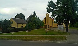
 Center of the village with the Church of Our Lady of Częstochowa | |
| Coordinates: 50°58′59″N 23°44′4″E / 50.98306°N 23.73444°E | |
| Country | |
| Voivodeship | Lublin |
| County | Chełm |
| Gmina | Białopole |
| Area | |
• Total | 5.24 km2 (2.02 sq mi) |
| Population (2008) | |
• Total | 883 |
| • Density | 170/km2 (440/sq mi) |
| Postal Code | 22-135 |
| Area Code | (+48) 82 |
| Vehicle registration | LCH |
Białopole [bʲawɔˈpɔlɛ] is a village in Chełm County, Lublin Voivodeship, in eastern Poland.[1] It is the seat of the gmina (administrative district) called Gmina Białopole. It lies approximately 26 kilometres (16 mi) south-east of Chełm and 87 km (54 mi) east of the regional capital Lublin.
References
[edit]

