Bheramara Upazila
Bheramara
ভেড়ামারা | |
|---|---|
 | |
 | |
| Coordinates: 24°1′N 88°59.5′E / 24.017°N 88.9917°E | |
| Country | |
| Division | Khulna |
| District | Kushtia |
| Area | |
• Total | 153.71 km2 (59.35 sq mi) |
| Population | |
• Total | 225,058 |
| • Density | 1,500/km2 (3,800/sq mi) |
| Time zone | UTC+6 (BST) |
| Postal code | 7040[2] |
| Area code | 07022[3] |
| Website | www.bheramara.net |
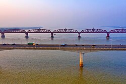
Bheramara (Bengali: ভেড়ামারা) is an upazila of Kushtia District in the Division of Khulna, Bangladesh.[4] The upazila lies along the Padma River, and the important Hardinge Bridge crosses the river between Bheramara Upazila and Ishwardi Upazila of Pabna District.
Geography
[edit]
Bheramara is located at 24°01′00″N 88°59′30″E / 24.0167°N 88.9917°E. It has 47586 households and total area 153.71 km2.
Bheramara sub-district is located within Kushtia district, Bangladesh and falls roughly within 23° 40′ – 24° 10′ N and 88° 45′ – 89° 20′ E. The town of Bheramara has an area of 3.26 km2 and a population of 20,676.
Agriculture is the main occupation of the people, and the major crops are paddy, wheat, mustard, sweet potato, sunflower, onion, garlic, betel leaf, tobacco, and sugarcane. The survey was conducted in Bheramara town and its immediate vicinity.[5]
Demographics
[edit]As of the 2011 Census of Bangladesh, Bheramara upazila had 47,586 households and a population of 200,084. 40,762 (20.37%) were under 10 years of age. Bheramara had an average literacy rate of 48.74%, compared to the national average of 51.8%, and a sex ratio of 1025 females per 1000 males. 30,747 (15.37%) of the population lived in urban areas.[7][8]
As of the 1991 Bangladesh census, Bheramara had a population of 144,221. Males constituted 51.55% of the population, and females made up 48.45%. This upazila's eighteen-up population was 72,279. Bheramara had an average literacy rate of 28.1% (7+ years), compared to the national average of 32.4% literate.[9]
Administration
[edit]Bheramara Thana was formed in 1906 and it was turned into an upazila on 7 November 1983.[4]
Bheramara Upazila is divided into Bheramara Municipality and six union parishads: Bahadurpur, Bahir Char, Chandgram, Dharmapur, Juniadaha, and Mokarimpur. The union parishads are subdivided into 43 mauzas and 78 villages.[7]
Bheramara Municipality is subdivided into 9 wards and 15 mahallas.[7]
See also
[edit]References
[edit]- ^ National Report (PDF). Population and Housing Census 2022. Vol. 1. Dhaka: Bangladesh Bureau of Statistics. November 2023. p. 400. ISBN 978-9844752016.
- ^ "Bangladesh Postal Code". Dhaka: Bangladesh Postal Department under the Department of Posts and Telecommunications of the Ministry of Posts, Telecommunications and Information Technology of the People's Republic of Bangladesh. 21 October 2024.
- ^ "Bangladesh Area Code". China: Chahaoba.com. 18 October 2024.
- ^ a b Arif Nisir (2012), "Bheramara Upazila", in Sirajul Islam and Ahmed A. Jamal (ed.), Banglapedia: National Encyclopedia of Bangladesh (Second ed.), Asiatic Society of Bangladesh
- ^ American-Eurasian Journal of Sustainable Agriculture, 3(3): 534-541, 2009 ISSN 1995-0748, American Eurasian Network for Scientific Information
- ^ Population and Housing Census 2022 - District Report: Kushtia (PDF). District Series. Dhaka: Bangladesh Bureau of Statistics. June 2024. ISBN 978-984-475-224-5.
- ^ a b c "Bangladesh Population and Housing Census 2011 Zila Report – Kushtia" (PDF). bbs.gov.bd. Bangladesh Bureau of Statistics.
- ^ "Community Tables: Kushtia district" (PDF). bbs.gov.bd. Bangladesh Bureau of Statistics. 2011. p. 103.
- ^ "Population Census Wing, BBS". Archived from the original on 2005-03-27. Retrieved November 10, 2006.

