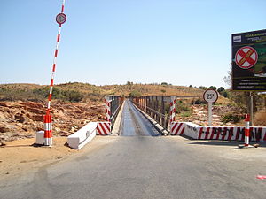
Betsiboka Bridge
Appearance

Betsiboka Bridge | |
|---|---|
| Coordinates | 16°56′17″S 46°57′04″E / 16.9380°S 46.9512°E |
| Carries | RN 4 |
| Crosses | Betsiboka River |
| Characteristics | |
| Total length | ≈350 meters |
| No. of lanes | 2 |
| Location | |
 | |
The Betsiboka Bridge is a truss bridge over the Betsiboka River, in the district of Maevatanana, which is a part of Betsiboka Region, Madagascar.[1] It is one of the longest bridge on the island, appr. 350 meters long.[1]
History
[edit]The first bridge was one of the three suspension bridges erected in Madagascar by the French company G. Leinekugel Le Cocq & Fils between 1931 and 1934.[2][3]
It was destroyed in World War II and, thereafter, replaced by the present truss bridge which was refurbished in 1980 and rehabilitated in 2015.[4][5]
See also
[edit]References
[edit]- ^ a b "Betsiboka Bridge". www.dangerousroads.org. Retrieved 2017-09-14.
- ^ Les ponts suspendus conçus, édifiés ou reconstruits par Gaston Leinekugel-le-Cocq de 1924 à 1950 on timbresponts.fr
- ^ A.C.: Les grands ponts de Madagascar et la technique nouvelle des ponts suspendus. In: Le Génie Civil, tome CVI, n° 2 of 12 January 1935, No. 2735, pp. 46–47 (online on Gallica)
- ^ "Travaux de réhabilitation du pont de Betsiboka ARM". Archived from the original on 2021-05-08. Retrieved 2021-01-29.
- ^ RN4 : Le pont de Betsiboka inauguré hier
