Besh-Ba-Gowah
This article needs additional citations for verification. (October 2015) |
Besh-Ba-Gowah | |
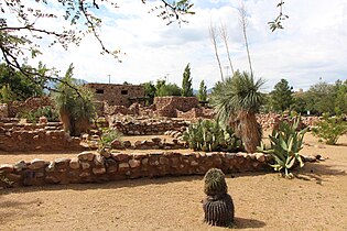
 Besh-Ba-Gowah, Facing southeast towards central plaza | |
| Nearest city | Globe, Arizona |
|---|---|
| Area | 2.5 acres (1.0 ha) |
| NRHP reference No. | 84000648[1] |
| Added to NRHP | May 9, 1984 |
Besh-Ba-Gowah is a 200-room prehistoric Salado masonry pueblo located atop a broad ridge overlooking Pinal Creek. The site is situated one mile southwest from Globe, Arizona and surrounded by a small city park and adjacent museum with excavated items including prehistoric pottery, stone and woven artifacts. The site is operated by the city as Besh Ba Gowah Archaeological Park and Museum.
Besh-Ba-Gowah was occupied by Salado populations between AD 1225 and AD 1400. "Salado" is the term applied to the complex of cultural attributes of the prehistoric peoples who inhabited the Globe/Miami and Tonto Basin regions between AD 1150 and AD 1450.[1]
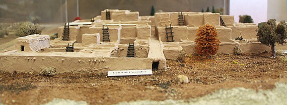
Besh-Ba-Gowah architecture consists of multi-storied, masonry room block clusters connected by long, narrow corridors or elongated plazas. These room blocks and corridors are situated around a large communal plaza area measuring 12 meters north–south by 27 meters east/west.[1]
Material recovered from Besh-Ba-Gowah has formed the foundation for the profession's current understanding and definition of the Salado culture concept. Thus, Besh-Ba-Gowah is considered one of the Salado culture "type sites".[1]

All walled architecture at Besh-Ba-Gowah consists of unshaped, large to moderate-sized, granite cobble masonry laid with a clay mortar. Evidence suggests interior room walls were commonly plastered with this mortar or a more calcareous mixture resulting in white-colored finished walls. There are some indications that at least selected exterior wall surfaces were also plastered with the original clay mortar. Often the basal masonry course consisted of upright vertical slabs, presently considered characteristic of Salado masonry architecture.[1]
Excavations at the Besh-Ba-Gowah site were funded originally by the Federal Emergency Relief Administration and then by the Works Projects Administration. The "ruin represents one of the few remaining, reconstructed and stabilized examples of archaeological projects undertaken within Arizona to alleviate critical unemployment during the Depression.[2]
The site was listed on the National Register of Historic Places in 1984.[1][2]
Gallery
[edit]-
Besh-Ba-Gowah, unexcavated rooms, Globe, AZ
-
Besh-Ba-Gowah, roof detail, Globe, AZ
-
Besh-Ba-Gowah, modern day, looking south west, Globe, AZ
-
Besh-Ba-Gowah diorama, looking south west, GlobeAZ
-
Besh-Ba-Gowah, diorama looking south down central corridor, Globe, AZ
-
Besh-Ba-Gowah, looking south down main corridor, Globe, AZ
References
[edit]- ^ a b c d e f "National Register Information System". National Register of Historic Places. National Park Service. July 9, 2010.
- ^ a b John W. Hohmann (1984). National Register of Historic Places Registration: Best-Ba-Gowah. National Archives. Retrieved May 25, 2021. Includes photos, including from 1937 and 1983. (Downloading may be slow.)
External links
[edit]- Besh Ba Gowah Archaeological Park and Museum – City of Globe
- Archaeological sites in Arizona
- Archaeological sites on the National Register of Historic Places in Arizona
- Buildings and structures in Globe, Arizona
- Museums in Gila County, Arizona
- Archaeological museums in Arizona
- Native American museums in Arizona
- National Register of Historic Places in Gila County, Arizona


