Belfair State Park
Appearance
| Belfair State Park | |
|---|---|
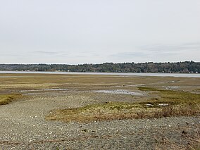
 Beach at Belfair State Park | |
| Location | Mason County, Washington, United States |
| Nearest city | Bremerton, Washington |
| Coordinates | 47°25′47″N 122°52′34″W / 47.42972°N 122.87611°W[1] |
| Area | 94 acres (38 ha) |
| Elevation | 10 ft (3.0 m)[1] |
| Designation | Washington state park |
| Established | 1952[2] |
| Administrator | Washington State Parks and Recreation Commission |
| Website | Belfair State Park |
Belfair State Park is a public recreation area located on Hood Canal three miles (4.8 km) southwest of Belfair in Mason County, Washington. The state park consists of 94 acres (38 ha) of tidal flats, wetlands, and beaches with a 3,720-foot (1,130 m) shoreline. Park activities include camping, fishing, swimming, clam digging, crabbing, birdwatching, and field sports.[3]
References
[edit]- ^ a b "Belfair State Park". Geographic Names Information System. United States Geological Survey, United States Department of the Interior.
- ^ "Marine Protected Areas in Washington" (PDF). Washington Department of Fish and Wildlife. December 2009. p. 39. Archived from the original (PDF) on October 26, 2017. Retrieved August 13, 2018.
- ^ "Belfair State Park". Washington State Parks and Recreation Commission. Retrieved August 25, 2016.
External links
[edit]- Belfair State Park Washington State Parks and Recreation Commission
- Belfair State Park Map Washington State Parks and Recreation Commission


