Beichuan Qiang Autonomous County
Beichuan County
北川县 | |
|---|---|
| 北川羌族自治县 Beichuan Qiang Autonomous County | |
 | |
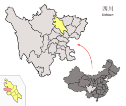
 Location of Beichuan County (lower left of the picture with colour of violet) within Mianyang City (yellow) and Sichuan | |
| Coordinates (Beichuan County government): 31°37′02″N 104°28′06″E / 31.6172°N 104.4682°E | |
| Country | China |
| Province | Sichuan |
| Prefecture-level city | Mianyang |
| County seat | Yongchang |
| Area | |
| • Total | 3,112 km2 (1,202 sq mi) |
| Elevation | 598 m (1,962 ft) |
| Population (2020)[1] | |
| • Total | 174,132 |
| • Density | 56/km2 (140/sq mi) |
| Time zone | UTC+8 (China Standard) |
| Postal code | 622750 |
| Area code | 0816 |
| Website | www |
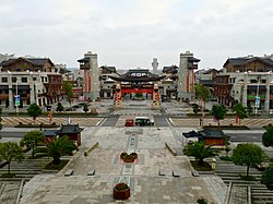
Beichuan Qiang Autonomous County (simplified Chinese: 北川羌族自治县; traditional Chinese: 北川羌族自治縣; pinyin: Běichuān Qiāngzú Zìzhì Xiàn; Qiang: Juda Rrmea nyujugvexueaji xae) is a county under the jurisdiction of Mianyang City in northern Sichuan province, China. It is located in an ethnically diverse mountainous region of Sichuan. Its Chinese name literally means "North" (bei) "River" (chuan). Its new county seat is located at Yongchang after the 2008 Sichuan earthquake.
Geography
[edit]Beichuan County has an area of 3,084 square kilometres (1,191 sq mi).[2] The county varies in elevation from 540 to 4,769 meters in height.[2]
The county's major rivers, which include the Tongkou River, the Anchang River, and the Pingtong River (平通河; Píngtōng Hé) belong to the larger Fu River watershed.[2]
History and culture
[edit]The first administrative county of Beichuan was set up in 564 A.D. during the Northern Zhou dynasty.[3] The Tang dynasty first created another county, Shiquan (Chinese: 石泉; pinyin: Shíquán) inside the original Beichuan county in 634 A.D., then in 651 A.D. merged Beichuan county into Shiquan.[3] The Republic of China changed the county name back to Beichuan in 1914 because there had been a Shiquan county in Shaanxi province before 564 A.D.[3]
In 1988, China granted Beichuan county the status of Qiang autonomy.[3] The Beichuan Qiang Autonomous County was formally created on July 6, 2003.[3]
Claim to Yu the Great
[edit]Beichuan was the first county in Sichuan to make the claim as the birthplace of Yu the Great, founder of the Xia dynasty and traditionally regarded as the first hereditary sovereign in Chinese history.[4] Although this claim is probably more commercial than historical, Beichuan was part of West Qiang (Chinese: 西羌) that some ancient records accredited as Yu's birthplace, just like the other three locations in Sichuan, namely Wenchuan, Dujiangyan, and Shifang, that raised similar claims.[5] Many places in other parts of China have made similar claims.
Great Sichuan Earthquake
[edit]
Also like the other three counties and towns in Sichuan holding claims to be the birthplace of Yu the Great, Beichuan is among the most severely hit of all disaster regions following the 2008 Sichuan earthquake, including the Beichuan High School campus, where more than 1,000 students lost their lives after two main buildings collapsed.[6] Beichuan's Party and government building also collapsed, and Yang Zesen, Beichuan's vice mayor then was among the victims. 80% of the county's buildings are said to have collapsed.[7]
The county town, which prior to the earthquake had a population of 20,000, is to be made into a memorial park, as the site has been deemed too vulnerable. The survivors of the quake have been relocated.[8]
The earthquake also caused a landslide on Mount Tangjia which dammed the Jian River and created the Tangjiashan Quake Lake. The lake was once in danger of causing the Tangjiashan Dam to collapse and catastrophically flood downstream communities, totalling over a million persons. On June 10, 2008, the lake spilled through an artificially constructed sluice channel and flooded the evacuated town. No casualties were caused.
Beichuan was at the center of one of two zones where seismic intensity were the highest at XI liedu during this earthquake and its aftershocks.[9] Since the earthquake, the central government has increased fortification intensity for seismic design for the old county town from VI to VIII.[10]
Administrative divisions
[edit]Beichuan County has 9 towns, 9 townships, and 1 ethnic township.[11][12]^
|
|
Demographics
[edit]Beichuan County had a population of 235,304 in 2017, of which 61.5% are Han Chinese, 36.6% of which are Qiang people (a Sino-Tibetan people related to Tibetans), 1.5% are Tibetans, 0.2% are Hui, and the remaining 0.2% belong to various other ethnic groups.[13]
Education
[edit]The county is home to 34 standard schools, of which, 24 are primary schools, 9 junior high schools, and 1 compulsory school.[14]
Beichuan also houses the Beichuan Red Army Elementary School.[15]
Climate
[edit]| Climate data for Beichuan, elevation 597 m (1,959 ft), (1991–2020 normals) | |||||||||||||
|---|---|---|---|---|---|---|---|---|---|---|---|---|---|
| Month | Jan | Feb | Mar | Apr | May | Jun | Jul | Aug | Sep | Oct | Nov | Dec | Year |
| Mean daily maximum °C (°F) | 9.3 (48.7) |
11.7 (53.1) |
16.3 (61.3) |
22.1 (71.8) |
25.9 (78.6) |
28.3 (82.9) |
30.0 (86.0) |
29.5 (85.1) |
24.7 (76.5) |
20.0 (68.0) |
15.5 (59.9) |
10.6 (51.1) |
20.3 (68.6) |
| Daily mean °C (°F) | 5.5 (41.9) |
7.8 (46.0) |
12.0 (53.6) |
17.1 (62.8) |
20.8 (69.4) |
23.5 (74.3) |
25.3 (77.5) |
24.8 (76.6) |
20.8 (69.4) |
16.4 (61.5) |
11.8 (53.2) |
6.8 (44.2) |
16.1 (60.9) |
| Mean daily minimum °C (°F) | 2.8 (37.0) |
5.0 (41.0) |
8.8 (47.8) |
13.3 (55.9) |
17.0 (62.6) |
20.0 (68.0) |
22.0 (71.6) |
21.6 (70.9) |
18.4 (65.1) |
14.2 (57.6) |
9.4 (48.9) |
4.3 (39.7) |
13.1 (55.5) |
| Average precipitation mm (inches) | 8.3 (0.33) |
11.6 (0.46) |
24.2 (0.95) |
48.7 (1.92) |
94.7 (3.73) |
123.9 (4.88) |
319.8 (12.59) |
329.8 (12.98) |
178.4 (7.02) |
73.1 (2.88) |
21.1 (0.83) |
6.2 (0.24) |
1,239.8 (48.81) |
| Average precipitation days (≥ 0.1 mm) | 7.1 | 8.1 | 11.3 | 12.9 | 14.8 | 14.8 | 16.5 | 16.8 | 17.8 | 16.8 | 9.4 | 5.3 | 151.6 |
| Average snowy days | 1.8 | 0.8 | 0 | 0 | 0 | 0 | 0 | 0 | 0 | 0 | 0 | 0.4 | 3 |
| Average relative humidity (%) | 75 | 74 | 71 | 70 | 69 | 74 | 78 | 79 | 84 | 83 | 81 | 77 | 76 |
| Mean monthly sunshine hours | 52.4 | 49.3 | 69.6 | 101.8 | 116.8 | 102.5 | 111.1 | 119.5 | 52.9 | 42.2 | 49.5 | 53.6 | 921.2 |
| Percent possible sunshine | 16 | 16 | 19 | 26 | 27 | 24 | 26 | 29 | 14 | 12 | 16 | 17 | 20 |
| Source: China Meteorological Administration[16][17] | |||||||||||||
References
[edit]- ^ "绵阳市第七次全国人口普查公报(第一号)——全市人口情况" (in Chinese). Government of Mianyang. 2021-05-28.
- ^ a b c 北川羌族自治县自然地理. www.beichuan.gov.cn. Archived from the original on 2018-06-17. Retrieved 2018-06-17.
- ^ a b c d e 北川羌族自治县历史沿革 [Administrative history of Beichuan Qiang Autonomous County] (in Simplified Chinese). Government of Beichuan. Archived from the original on 20 August 2008. Retrieved 2018-06-17.
- ^ 禹羌文化 [Yu and Qiang culture] (in Simplified Chinese). Government of Beichuan. 2008-06-17. Archived from the original on 2008-12-01. Retrieved 2008-10-01.
- ^ CHEN, Sisi (2008-06-25). 发现西羌古道有关遗迹 "大禹故乡"迷雾更浓" [Discovery of ancient West Qiang pathway thickens the mystery surrounding "Birthplace of Yu the Great"]. 四川日报 [Sichuan Daily] (in Simplified Chinese). Retrieved 2008-10-01.
- ^ 四川北川中学震灾纪实 [Eye witnesses of the earthquake disaster in Beichuan Middle School, Sichuan] (in Simplified Chinese). bczx.changhong.com. Archived from the original on 8 September 2008. Retrieved 2008-10-01.
- ^ "Death toll in China earthquake rises to 7,600". Chicago Tribune. Archived from the original on 2008-05-16. Retrieved 2008-05-12.
- ^ Beichuan county town to be made a memorial, China Daily, May 23, 2008.
- ^ 汶川8.0级地震烈度分布图 [Seismic intensity map of the M8.0 Wenchuan earthquake] (in Simplified Chinese). CEA. 2008-08-29. Archived from the original on 8 September 2008. Retrieved 2008-09-10.
- ^ Xu, Zhengzhong (徐正忠); Wang, Yayong (王亚勇); et al. (2001). 《建筑抗震设计规范》(GB 500011-2001) (2008 年局部修订) 附录 A 我国主要城镇抗震设防烈度、设计基本地震加速度和设计地震分组 [Code for seismic design of buildings (GB 500011-2001) (partially revised in 2008), Appendix A] (in Simplified Chinese). Ministry of Housing and Urban-Rural Development of PRC (MOHURD, 中华人民共和国住房和城乡建设部). Archived from the original on 13 October 2008. Retrieved 2008-09-29.
{{cite journal}}: Cite journal requires|journal=(help) Partially revised in 2008 - ^ (in Chinese) National Bureau of Statistics - Beichuan County.
- ^ 四川省人民政府关于同意绵阳市调整部分乡镇行政区划的批复(川府民政〔2019〕27号). sc.gov.cn (in Chinese). 2019-12-26. Archived from the original on 2020-07-06. Retrieved 2020-07-06.
- ^ 2017年北川羌族自治县民族人口年报. Beichuan Qiang Autonomous County Government (in Chinese). 2018-06-08. Archived from the original on 2020-07-06. Retrieved 2020-07-06.
- ^ 北川羌族自治县教育和体育局 关于义务教育学校2020年秋季招生公告. Beichuan Qiang Autonomous County Government (in Chinese). 2020-06-09. Archived from the original on 2020-07-07. Retrieved 2020-07-06.
- ^ "See the Patriotic Red Army School Students in China". Time. 2015-02-13. Retrieved 2017-02-21.
- ^ 中国气象数据网 – WeatherBk Data (in Simplified Chinese). China Meteorological Administration. Retrieved 17 September 2023.
- ^ 中国气象数据网 (in Simplified Chinese). China Meteorological Administration. Retrieved 17 September 2023.
External links
[edit]- Official website of Beichuan County (in Chinese)

