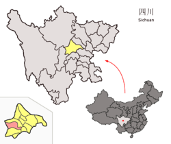
Dayi County
Appearance
Dayi County
大邑县 | |||||||||||||||||||||||||||||||||||||||||||||||||||||||||||||||
|---|---|---|---|---|---|---|---|---|---|---|---|---|---|---|---|---|---|---|---|---|---|---|---|---|---|---|---|---|---|---|---|---|---|---|---|---|---|---|---|---|---|---|---|---|---|---|---|---|---|---|---|---|---|---|---|---|---|---|---|---|---|---|---|
 | |||||||||||||||||||||||||||||||||||||||||||||||||||||||||||||||
 Location of Dayi County in Sichuan | |||||||||||||||||||||||||||||||||||||||||||||||||||||||||||||||
| Coordinates: 30°35′17″N 103°32′10″E / 30.588°N 103.536°E[1] | |||||||||||||||||||||||||||||||||||||||||||||||||||||||||||||||
| Country | China | ||||||||||||||||||||||||||||||||||||||||||||||||||||||||||||||
| Province | Sichuan | ||||||||||||||||||||||||||||||||||||||||||||||||||||||||||||||
| Sub-provincial city | Chengdu | ||||||||||||||||||||||||||||||||||||||||||||||||||||||||||||||
| County seat | Jinyuan Subdistrict | ||||||||||||||||||||||||||||||||||||||||||||||||||||||||||||||
| Area | |||||||||||||||||||||||||||||||||||||||||||||||||||||||||||||||
• Total | 1,548 km2 (598 sq mi) | ||||||||||||||||||||||||||||||||||||||||||||||||||||||||||||||
| Population (2020)[2] | |||||||||||||||||||||||||||||||||||||||||||||||||||||||||||||||
• Total | 515,962 | ||||||||||||||||||||||||||||||||||||||||||||||||||||||||||||||
| • Density | 378/km2 (980/sq mi) | ||||||||||||||||||||||||||||||||||||||||||||||||||||||||||||||
| Time zone | UTC+8 (China Standard) | ||||||||||||||||||||||||||||||||||||||||||||||||||||||||||||||
| Postal code | 6113XX | ||||||||||||||||||||||||||||||||||||||||||||||||||||||||||||||
| Chengdu district map |
| ||||||||||||||||||||||||||||||||||||||||||||||||||||||||||||||
Dayi County (Chinese: 大邑县; pinyin: Dàyì Xiàn) is a county of the City of Chengdu, capital city of Sichuan, China. It is Chengdu City's westernmost division, bordering the prefecture-level divisions of Ya'an to the south and the Ngawa Tibetan and Qiang Autonomous Prefecture to the north.
The Jianchuan Museum Cluster is located in the town of Anren, Dayi County, about one hour's drive from the provincial capital Chengdu. It consists of 15 museums which showcase China's largest private collection of artifacts amassed during the last 60–70 years.
Administrative divisions
[edit]Dayi County administers 3 subdistricts and 8 towns:[3]
- subdistricts
- Jinyuan 晋原街道
- Shaqu 沙渠街道
- Qingxia 青霞街道
- towns
- Wangsi 王泗镇
- Xinchang 新场镇
- Yuelai 悦来镇
- Anren 安仁镇
- Chujiang 䢺江镇
- Huashuiwan 花水湾镇
- Xiling 西岭镇
- Heming 鹤鸣镇
Climate
[edit]| Climate data for Dayi, elevation 545 m (1,788 ft), (1991–2016 normals, extremes 1981–2010) | |||||||||||||
|---|---|---|---|---|---|---|---|---|---|---|---|---|---|
| Month | Jan | Feb | Mar | Apr | May | Jun | Jul | Aug | Sep | Oct | Nov | Dec | Year |
| Record high °C (°F) | 17.9 (64.2) |
22.9 (73.2) |
31.2 (88.2) |
32.2 (90.0) |
35.1 (95.2) |
36.2 (97.2) |
36.6 (97.9) |
37.7 (99.9) |
35.3 (95.5) |
29.5 (85.1) |
26.0 (78.8) |
18.7 (65.7) |
37.7 (99.9) |
| Mean daily maximum °C (°F) | 9.3 (48.7) |
12.2 (54.0) |
16.9 (62.4) |
22.6 (72.7) |
26.6 (79.9) |
28.5 (83.3) |
30.3 (86.5) |
30.1 (86.2) |
26.0 (78.8) |
21.1 (70.0) |
16.3 (61.3) |
10.9 (51.6) |
20.9 (69.6) |
| Daily mean °C (°F) | 5.8 (42.4) |
8.3 (46.9) |
12.1 (53.8) |
17.2 (63.0) |
21.4 (70.5) |
24.0 (75.2) |
25.7 (78.3) |
25.3 (77.5) |
21.9 (71.4) |
17.5 (63.5) |
12.8 (55.0) |
7.5 (45.5) |
16.6 (61.9) |
| Mean daily minimum °C (°F) | 3.2 (37.8) |
5.5 (41.9) |
8.6 (47.5) |
13.2 (55.8) |
17.5 (63.5) |
20.6 (69.1) |
22.4 (72.3) |
21.9 (71.4) |
19.3 (66.7) |
15.3 (59.5) |
10.4 (50.7) |
5.0 (41.0) |
13.6 (56.4) |
| Record low °C (°F) | −4.5 (23.9) |
−3.7 (25.3) |
−2.1 (28.2) |
4.1 (39.4) |
6.5 (43.7) |
14.2 (57.6) |
16.3 (61.3) |
16.4 (61.5) |
12.3 (54.1) |
3.1 (37.6) |
0.5 (32.9) |
−5.1 (22.8) |
−5.1 (22.8) |
| Average precipitation mm (inches) | 10.5 (0.41) |
14.6 (0.57) |
31.8 (1.25) |
57.1 (2.25) |
84.7 (3.33) |
111.2 (4.38) |
246.0 (9.69) |
278.6 (10.97) |
137.3 (5.41) |
57.2 (2.25) |
21.9 (0.86) |
9.5 (0.37) |
1,060.4 (41.74) |
| Average precipitation days (≥ 0.1 mm) | 9.1 | 10.0 | 13.0 | 14.6 | 14.8 | 16.8 | 16.1 | 15.8 | 17.5 | 16.4 | 9.8 | 7.9 | 161.8 |
| Average snowy days | 1.1 | 0.3 | 0 | 0 | 0 | 0 | 0 | 0 | 0 | 0 | 0 | 0.3 | 1.7 |
| Average relative humidity (%) | 82 | 80 | 79 | 78 | 74 | 79 | 83 | 83 | 84 | 85 | 83 | 83 | 81 |
| Mean monthly sunshine hours | 46.2 | 51.6 | 76.9 | 105.4 | 106.9 | 100.8 | 121.0 | 125.4 | 60.4 | 49.2 | 51.8 | 50.9 | 946.5 |
| Percent possible sunshine | 14 | 16 | 21 | 27 | 25 | 24 | 28 | 31 | 16 | 14 | 17 | 16 | 21 |
| Source: China Meteorological Administration[4][5] | |||||||||||||
References
[edit]- ^ "Dayi" (Map). Google Maps. Retrieved 2014-07-02.
- ^ 我市2010年第六次全国人口普查数据公报 (in Simplified Chinese). Government of Chengdu. 2011-05-13. Retrieved 2011-08-04.
- ^ 2023年统计用区划代码和城乡划分代码:大邑县 (in Simplified Chinese). National Bureau of Statistics of China.
- ^ 中国气象数据网 – WeatherBk Data (in Simplified Chinese). China Meteorological Administration. Retrieved 14 April 2023.
- ^ 中国气象数据网 (in Simplified Chinese). China Meteorological Administration. Retrieved 14 April 2023.
External links
[edit]Wikimedia Commons has media related to Dayi County.


