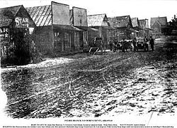
Bee Branch, Arkansas
Bee Branch, Arkansas | |
|---|---|
 Picture of Bee Branch taken in 1912. | |
| Coordinates: 35°27′22″N 92°23′42″W / 35.45611°N 92.39500°W | |
| Country | United States |
| State | Arkansas |
| County | Van Buren County |
| Elevation | 778 ft (237 m) |
| Population (2020) | |
• Total | 293 |
| Time zone | UTC-6 (Central (CST)) |
| • Summer (DST) | UTC-5 (CDT) |
| ZIP code | 72013[2] |
| GNIS feature ID | 2805621[1] |
Bee Branch is an unincorporated community and census-designated place (CDP) in Van Buren County, Arkansas, United States. It was first listed as a CDP in the 2020 census with a population of 293.[3]
More than 70% of the local population consist of married couples.[2] The majority of the population were born out-of-state and exclusively speak the English language.[2] The nearest towns are Clinton and Fairfield Bay.
History
[edit]The community has had a post office since Willie D. Neal was named postmaster in 1860. When the post office moved in 1879 near the present-day intersection of U.S. 65 and Highway 92, it applied for the name Crossroads, but was rejected as it had already been duplicated in several parts of the state. The name Bee Branch was chosen for a large beehive in a tree near the post office.[4]
Bee Branch was indirectly affected by an outbreak of tornadoes in November 2005.
Climate
[edit]The warmest summers that Bee Branch has witnessed occurred in 1998, 2003, 2005, 2006, 2007, 2009, 2010, 2012, 2013, 2014, 2015 and 2016.[5]
Education
[edit]Public education in the townsite is provided by South Side School District,[6][7] which operates South Side High School.
Infrastructure
[edit]The community is located near secondary roads and no Interstate highways in the immediate area. U.S. Route 65 is the most major highway to go through Bee Branch.
Demographics
[edit]| Census | Pop. | Note | %± |
|---|---|---|---|
| 2020 | 293 | — | |
| U.S. Decennial Census[8] 2020[9] | |||
2020 census
[edit]| Race / Ethnicity | Pop 2020[9] | % 2020 |
|---|---|---|
| White alone (NH) | 251 | 85.67% |
| Black or African American alone (NH) | 2 | 0.68% |
| Native American or Alaska Native alone (NH) | 3 | 1.02% |
| Asian alone (NH) | 0 | 0.00% |
| Pacific Islander alone (NH) | 0 | 0.00% |
| Some Other Race alone (NH) | 1 | 0.34% |
| Mixed Race/Multi-Racial (NH) | 19 | 6.48% |
| Hispanic or Latino (any race) | 17 | 5.80% |
| Total | 293 | 100.00% |
Notable people
[edit]Bee Branch is also the home town of fisherman Larry Nixon.[10]
Arkansas State Representative Kim Hammer, a Baptist clergyman from Saline County, was reared in Bee Branch and graduated from South Side High School.
Jim McKnight, professional baseball player, whose son also played in the Major Leagues, was born in Bee Branch.
Amber Straughn, NASA astronomer and James Webb Space Telescope Deputy Project Scientist, was raised in Bee Branch and graduated from South Side High School in 1998.
References
[edit]- ^ a b U.S. Geological Survey Geographic Names Information System: Bee Branch, Arkansas
- ^ a b c General information about Bee Branch, Arkansas Archived July 22, 2011, at the Wayback Machine at PikPuk
- ^ "Bee Branch CDP, Arkansas". United States Census Bureau. Retrieved April 7, 2022.
- ^ Trower, Kathy (July 4, 2004). "Bee Branch in Van Buren County was literally named after beehive". Arkansas Democrat-Gazette (River Valley & Ozark ed.). Little Rock: WEHCO Media. p. 88. Retrieved April 26, 2020 – via NewsBank.
- ^ "Global Analysis - Annual 2016". NOAA. Retrieved January 19, 2017.
- ^ "SCHOOL DISTRICT REFERENCE MAP (2010 CENSUS): Van Buren County, AR." U.S. Census Bureau. Retrieved on June 2, 2018.
- ^ "General Highway Map Van Buren County, Arkansas" (PDF). Arkansas Department of Transportation. Retrieved March 17, 2021. - See Bee Branch on the map, compare to the school district map.
- ^ "Decennial Census of Population and Housing by Decades". US Census Bureau.
- ^ a b "P2 HISPANIC OR LATINO, AND NOT HISPANIC OR LATINO BY RACE – 2020: DEC Redistricting Data (PL 94-171) – Bee Branch CDP, Arkansas". United States Census Bureau.
- ^ Larry Nixon information at Bassmaster


