Beaver Dam Lake, New York
Beaver Dam Lake, New York | |
|---|---|
 Beaverdam Lake, the lake the community is named after | |
| Coordinates: 41°26′39″N 74°7′4″W / 41.44417°N 74.11778°W | |
| Country | United States |
| State | New York |
| County | Orange |
| Towns | Blooming Grove Cornwall New Windsor |
| Area | |
• Total | 2.74 sq mi (7.10 km2) |
| • Land | 2.44 sq mi (6.32 km2) |
| • Water | 0.30 sq mi (0.78 km2) 10.95% |
| Elevation | 331 ft (101 m) |
| Population (2020) | |
• Total | 2,609 |
| • Density | 1,069.26/sq mi (412.90/km2) |
| Time zone | UTC-5 (Eastern (EST)) |
| • Summer (DST) | UTC-4 (EDT) |
| ZIP Codes | |
| Area code | 845 |
| FIPS code | 36-05188 |
| GNIS feature ID | 2652336[2] |
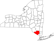
Beaver Dam Lake is a census-designated place (CDP) in the towns of New Windsor, Blooming Grove, and Cornwall in Orange County, New York, United States. As of the 2020 census, it had a population of 2,609.[3]
The CDP is in eastern Orange County, bordered to the west by the village of Washingtonville and to the south by Salisbury Mills. The community surrounds Beaverdam Lake, which drains south to Moodna Creek at Salisbury Mills. Moodna Creek flows into the Hudson River between New Windsor and Cornwall-on-Hudson.
New York State Route 94 forms the southern edge of the CDP. It leads northeast 6 miles (10 km) to New Windsor and southwest 10 miles (16 km) to Chester. Newburgh is 8 miles (13 km) to the northeast, and Middletown is 19 miles (31 km) to the west.
Demographics
[edit]As of the census of 2020, there were 2,609 people residing in the area.
| Census | Pop. | Note | %± |
|---|---|---|---|
| 2010 | 2,242 | — | |
| 2020 | 2,609 | 16.4% | |
| U.S. Decennial Census[4] | |||
Geography
[edit]According to the United States Census Bureau, the CDP has a total area of 2.74 square miles (7.1 km2), of which 2.44 square miles (6.3 km2) is land and 0.30 square miles (0.78 km2) (10.95%) is water.
References
[edit]- ^ "ArcGIS REST Services Directory". United States Census Bureau. Retrieved September 20, 2022.
- ^ "Beaver Dam Lake Census Designated Place". Geographic Names Information System. United States Geological Survey, United States Department of the Interior.
- ^ "2020 Census Redistricting Data: Beaver Dam Lake CDP, New York". data.census.gov. U.S. Census Bureau. Retrieved January 31, 2023.
- ^ "Census of Population and Housing". Census.gov. Retrieved June 4, 2016.


