Beaumont Street, Newcastle
Appearance
This article needs additional citations for verification. (May 2018) |
Beaumont Street | |
|---|---|
 | |
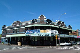
| The Kent Hotel, est. 1924, is a landmark on Beaumont Street | |
 | |
| Coordinates | |
| General information | |
| Type | Street |
| Location | Newcastle |
| Length | 2.3 km (1.4 mi) |
| Maintained by | Newcastle City Council |
| Major junctions | |
| North end | Maitland Road Islington, New South Wales |
| |
| South end | Glebe Road Hamilton South, New South Wales |
| Location(s) | |
| Region | Hunter Region |
| LGA(s) | City of Newcastle |
| Suburb(s) | |
Beaumont Street (/ˈboʊmɒnt/ BOH-mont) is a major street in Hamilton[1] Newcastle[2], Australia running from the Islington antiques district on Maitland Road to Henry Park in Hamilton South. While the southernmost end of the street is primarily residential, the stretch between Tudor and Donald Streets is Newcastle's version of "Little Italy", and a significant site for the Italian community in Newcastle.[3] A walking tour of Hamilton can help you explore the local area, shops, cafes and restaurants.
See also
[edit]References
[edit]- ^ City of Newcastle (26 May 2021). "Hamilton". Archived from the original on 8 March 2017. Retrieved 26 May 2021.
- ^ "Home". City of Newcastle. 26 May 2021. Archived from the original on 30 January 2007. Retrieved 26 May 2021.
- ^ Catherine, Kevin (1 January 2001). "A history of Italian settlement in New South Wales". NSW Heritage Office, Sydney.

