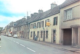
Beaumont-Hague
Appearance
Beaumont-Hague | |
|---|---|
Part of La Hague | |
 Rue Jallot | |
| Coordinates: 49°39′52″N 1°50′08″W / 49.6644°N 1.8356°W | |
| Country | France |
| Region | Normandy |
| Department | Manche |
| Arrondissement | Cherbourg |
| Canton | La Hague |
| Commune | La Hague |
| Area 1 | 7.90 km2 (3.05 sq mi) |
| Population (2019)[1] | 1,356 |
| • Density | 170/km2 (440/sq mi) |
| Time zone | UTC+01:00 (CET) |
| • Summer (DST) | UTC+02:00 (CEST) |
| Postal code | 50440 |
| Elevation | 5–179 m (16–587 ft) (avg. 166 m or 545 ft) |
| 1 French Land Register data, which excludes lakes, ponds, glaciers > 1 km2 (0.386 sq mi or 247 acres) and river estuaries. | |
Beaumont-Hague (French pronunciation: [bomɔ̃ aɡ], before 1991: Beaumont)[2] is a former commune in the Manche department in the Normandy region in northwestern France. On 1 January 2017, it was merged into the new commune La Hague.[3]
Population
[edit]
|
|
Heraldry
[edit] |
The arms of Beaumont-Hague are blazoned :Azure, on a chevron argent between 3 trefoils Or, 3 martlets azure the 2 in the base respectant.
|
See also
[edit]References
[edit]- ^ Téléchargement du fichier d'ensemble des populations légales en 2019, INSEE
- ^ Décret du 13 décembre 1991 portant changement de nom de communes, Légifrance.
- ^ Arrêté préfectoral 27 September 2016 (in French)
Wikimedia Commons has media related to Beaumont-Hague.


