Baucau
You can help expand this article with text translated from the corresponding article in German. (December 2010) Click [show] for important translation instructions.
|
Baucau | |
|---|---|
City | |
| |
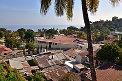
 View of the Old City, Baucau | |
 Location in Baucau Municipality | |
| Coordinates: 8°27′46″S 126°27′13″E / 8.46278°S 126.45361°E | |
| Country | East Timor |
| Municipality | Baucau |
| Sucos (villages) | List |
| Area | |
• Total | 369.53 km2 (142.68 sq mi) |
| Elevation | 336 m (1,102 ft) |
| Population (2015) | |
• Total | 14,961 |
| • Density | 40/km2 (100/sq mi) |
| Time zone | UTC+09:00 (TLT) |
| Climate | Aw |
Baucau (Portuguese: Baucau, Tetum: Baukau) is the second-largest city in East Timor, after Dili, the capital, which lies 122 km (76 mi) to its west.
Baucau has about 16,000 inhabitants, and is the capital of Baucau municipality, located in the eastern part of the country. In the times of Portuguese Timor, Baucau was little more than an overgrown village,[1] and for part of those times was called Vila Salazar, after the Portuguese dictator António de Oliveira Salazar.
Geography
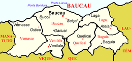
[edit]The administrative post of Baucau is divided into 11 villages (sucos).[2]
- Suco Bahú
- Suco Bucoli
- Suco Buibau
- Suco Buruma
- Suco Caibada Uaimua
- Suco Samalari
- Suco Seiçal
- Suco Tirilolo
- Suco Triloka
- Suco Gariuai
- Suco Uailili
Infrastructure
[edit]
Much of the infrastructure of the city and the surrounding area was damaged or destroyed by pro-Indonesian militia during the violence that followed the referendum for independence in 1999. Nevertheless, in the old part of Baucau there survive a few relics from the Portuguese colonial era, such as large colonial houses, churches, and public buildings. One of these is the Pousada de Baucau, a large pink hotel whose restaurant has views of the ocean.
The shops, restaurants, and street market stalls (predominantly fruit and vegetable sellers) conduct business, although unemployment, particularly among the young, is very high. There are a few successful experiments that have converted old war-oriented businesses into light engineering, new businesses such as East Timor Roofing that has generated employment and training opportunities,[3] and a number of small businesses are beginning in the areas of hygiene and health, food production and processing, transport, small retail, and tourism. The convent next to the Pousada de Baucau has a small retail outlet selling locally produced hand crafts.
The Instituto Católico para a Formação de Professores (ICFP) – the Catholic Teachers College – is owned by the diocese and is responsible for training future and untrained teachers for Timor-Leste. With more than 300 graduates teaching throughout the country, and more than 400 teachers with upgraded qualifications, ICFP is dedicated to rebuilding the country through education of future generations.[citation needed]
Baucau also has a hospital, a nursing school and a swimming pool owned by the Pousada de Baucau.
Climate
[edit]| Climate data for Baucau (1917–1963) | |||||||||||||
|---|---|---|---|---|---|---|---|---|---|---|---|---|---|
| Month | Jan | Feb | Mar | Apr | May | Jun | Jul | Aug | Sep | Oct | Nov | Dec | Year |
| Record high °C (°F) | 36.0 (96.8) |
35.0 (95.0) |
34.0 (93.2) |
36.0 (96.8) |
35.0 (95.0) |
35.0 (95.0) |
35.0 (95.0) |
35.0 (95.0) |
38.0 (100.4) |
37.0 (98.6) |
37.0 (98.6) |
36.0 (96.8) |
38.0 (100.4) |
| Mean daily maximum °C (°F) | 27.5 (81.5) |
27.3 (81.1) |
28.2 (82.8) |
28.8 (83.8) |
28.4 (83.1) |
27.8 (82.0) |
27.6 (81.7) |
28.2 (82.8) |
29.4 (84.9) |
30.1 (86.2) |
30.2 (86.4) |
28.8 (83.8) |
28.5 (83.3) |
| Daily mean °C (°F) | 23.8 (74.8) |
23.6 (74.5) |
24.1 (75.4) |
24.1 (75.4) |
23.9 (75.0) |
23.0 (73.4) |
22.8 (73.0) |
23.1 (73.6) |
24.0 (75.2) |
25.6 (78.1) |
25.7 (78.3) |
24.8 (76.6) |
24.0 (75.2) |
| Mean daily minimum °C (°F) | 22.0 (71.6) |
21.5 (70.7) |
20.9 (69.6) |
20.7 (69.3) |
20.5 (68.9) |
19.6 (67.3) |
19.1 (66.4) |
18.5 (65.3) |
18.5 (65.3) |
17.8 (64.0) |
20.9 (69.6) |
21.5 (70.7) |
20.1 (68.2) |
| Record low °C (°F) | 17.3 (63.1) |
16.4 (61.5) |
16.1 (61.0) |
14.4 (57.9) |
13.8 (56.8) |
13.3 (55.9) |
12.2 (54.0) |
13.2 (55.8) |
13.2 (55.8) |
14.7 (58.5) |
17.2 (63.0) |
16.9 (62.4) |
12.2 (54.0) |
| Average rainfall mm (inches) | 213.2 (8.39) |
220.7 (8.69) |
152.3 (6.00) |
153.7 (6.05) |
95.5 (3.76) |
37.9 (1.49) |
19.5 (0.77) |
10.6 (0.42) |
4.8 (0.19) |
7.2 (0.28) |
76.4 (3.01) |
186.0 (7.32) |
1,177.8 (46.37) |
| Average rainy days (≥ 0.1 mm) | 20 | 17 | 16 | 15 | 10 | 6 | 4 | 2 | 0 | 1 | 7 | 15 | 113 |
| Average relative humidity (%) | 84 | 87 | 80 | 77 | 71 | 67 | 63 | 56 | 55 | 58 | 67 | 78 | 70 |
| Mean monthly sunshine hours | 158.1 | 149.7 | 213.9 | 207.0 | 251.1 | 228.0 | 263.5 | 297.6 | 300.0 | 313.1 | 303.0 | 204.6 | 2,889.6 |
| Mean daily sunshine hours | 5.1 | 5.3 | 6.9 | 6.9 | 8.1 | 7.6 | 8.5 | 9.8 | 10.0 | 10.1 | 10.1 | 6.6 | 7.9 |
| Source: Deutscher Wetterdienst[4] | |||||||||||||
Religion
[edit]Baucau is the seat of the Roman Catholic Diocese of Baucau, one of the three bishoprics in East Timor. It was founded on 30 November 1996, when the bishopric in Dili split. Its bishop is Basilio do Nascimento.
Transportation
[edit]Six kilometers from the city lies the Cakung Airport (code IATA: BCH), a.k.a. LANUD for the local people. It has what is currently the country's longest airport runway, as Dili's Lobato International Airport can only serve small aircraft like the Boeing 737. It served as the country's principal airport before the Indonesian invasion in 1975, when it was taken over by the Indonesian military.
-
Municipal market building in Baucau
-
The beach in Baucau
-
Church of Baucau
-
Fields of Baucau area
-
Colonial building
-
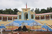
Administration building
-
Fisher on the beach
-
Upper part of Baucau city
-
Huts in the lower part
-
Public pool in Baucau
-
Street from city center to the beach
-
Wall painting
-
Wall painting
References
[edit]- ^ Gunn, Geoffrey C (2011). Historical Dictionary of East Timor. Lanham, Maryland: Scarecrow Press. pp. 48–49. ISBN 9780810867543.
- ^ Baucau em Numeros 2018 Archived 17 November 2020 at the Wayback Machine
- ^ East Timor Roofing website [permanent dead link]
- ^ "Klimatafel von Baucau, Insel Timor / Ost-Timor" (PDF). Baseline climate means (1961–1990) from stations all over the world (in German). Deutscher Wetterdienst. Retrieved 29 January 2016.
Further reading
[edit]- Simmons, Graham (11 September 2003). "Back to Baucau: Culture Schlock In East Timor". ThingsAsian. Retrieved 14 February 2022.
External links
[edit]![]() Baucau travel guide from Wikivoyage
Baucau travel guide from Wikivoyage


