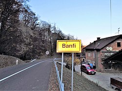
Banfi, Croatia
Banfi | |
|---|---|
Village | |
 Banfi Manor | |
| Coordinates: 46°30′37″N 16°16′52″E / 46.51028°N 16.28111°E | |
| Country | Croatia |
| County | Međimurje County |
| Municipality | Štrigova |
| Area | |
• Total | 4.6 km2 (1.8 sq mi) |
| Population (2021)[2] | |
• Total | 209 |
| • Density | 45/km2 (120/sq mi) |
| Time zone | UTC+1 (CET) |
| • Summer (DST) | UTC+2 (CEST) |
Banfi is a village in northern Croatia, part of the Štrigova municipality within Međimurje County. The village is located at the border with Slovenia.
Name
[edit]The village is named after noble family Bánffy, in whose possession it was. In Hungarian language village is called Bánfihegy ("Banffy's hills").
History
[edit]At the site of today's Banfi manor, there was an older castle built by a members of noble family Bánffy de Alsólendva. Castle was probably built in the 14th century.[3]
An urbarium from year 1672 mentions a cellar (Baanffy Cellarium)[4] and vineyards (Vinea Banffi in monte Strigowsky).[5] The cellar and vineyards were in possession of Zrinski noble family.[6]
Banfi Manor, most notable building in village, was built in 18th century on the ruins of castle Banffy.[7]
Geography
[edit]
Banfi is located in part of Međimurje called Gornje Međimurje. Banfi is about 20 kilometres northwest from Čakovec, and some 110 kilometres north of Zagreb.
Landscape of Banfi consist of low hills called Međimurske gorice, covered with vineyards, orchards and woodlands.
There is a border crossing with Slovenia in Banfi.[8] Border crossing is located on road that connects county seat Čakovec with town of Ljutomer in Slovenia.
Banfi had a population of 262 in 2011 census.[9] Banfi is experiencing population decline since the 1960s.
|
| ||||||||||||||||||||||||||||||||||||
| [9][10] | |||||||||||||||||||||||||||||||||||||
References
[edit]- ^ Register of spatial units of the State Geodetic Administration of the Republic of Croatia. Wikidata Q119585703.
- ^ "Population by Age and Sex, by Settlements" (xlsx). Census of Population, Households and Dwellings in 2021. Zagreb: Croatian Bureau of Statistics. 2022.
- ^ Horvat, Anđela (1956). Spomenici arhitekture i likovnih umjetnosti u Međumurju (in Croatian). Zagreb: Konzervatorski zavod Zagreb. p. 35.
- ^ "HU MNL OL E 156 - a. - Fasc. 092. - No. 013 / b." Hungaricana (in Latin). p. 32. Retrieved October 24, 2020.
- ^ "HHU MNL OL E 156 - a. - Fasc. 003. - No. 005 / a." Hungaricana (in Latin). p. 30. Retrieved October 24, 2020.
- ^ Kalšan, Vladimir (1993). "Prilog za povijest vinogradarstva u Međimurju". Muzejski Vjesnik (in Croatian). 16. Muzejsko društvo Sjeverzapadne Hrvatske: 79. Retrieved October 24, 2020 – via HRČAK.
- ^ Đurić, Tomislav; Feletar, Dragutin (1992). Stari gradovi, dvorci i crkve sjeverozapadne Hrvatske (in Croatian). Koprivnica. pp. 75–76.
{{cite book}}: CS1 maint: location missing publisher (link) - ^ "Prostorni plan uređenja općine Štrigova" (in Croatian). Zavod za prostorno uređenje Međimurske Županije. October 2005. p. 84. Retrieved 2020-10-20.
- ^ a b "Population by Age and Sex, by Settlements, 2011 Census: Banfi". Census of Population, Households and Dwellings 2011. Zagreb: Croatian Bureau of Statistics. December 2012.
- ^ "Naselja i stanovništvo Republike Hrvatske". Croatian Bureau of Statistics. Retrieved 10 October 2020.

