Banatić
Banatić
Банатић | |
|---|---|
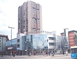
 Banatić, Jaša Tomić Boulevard | |
 | |
| Country | |
| Province | Vojvodina |
| District | South Bačka |
| Municipality | Novi Sad |
| Time zone | UTC+1 (CET) |
| • Summer (DST) | UTC+2 (CEST) |
| Area code | +381(0)21 |
| Car plates | NS |
Banatić (Serbian: Банатић) is an urban neighborhood of the city of Novi Sad, Serbia. Its name means "a little Banat".
Borders
[edit]The southern border of Banatić is Bulevar kralja Petra I (King Petar I Boulevard), the eastern border is Bulevar oslobođenja (Liberation Boulevard), the north-eastern borders are Bulevar Jaše Tomića (Jaša Tomić Boulevard) and Kisačka ulica (Kisač street), the northern border is railway Belgrade-Subotica, the north-western border is ulica Kornelija Stankovića (Kornelije Stanković Street), and the western border is Rumenačka ulica (Rumenka Street).
Neighbouring city quarters
[edit]

The neighbouring city quarters are: Detelinara in the west, Sajmište in the south, Rotkvarija and Salajka in the east, and Pervazovo Naselje and Industrijska Zona Jug in the north.
Features
[edit]The city main train and bus stations are located in Banatić.
Gallery
[edit]-
Banatić, Jaša Tomić Boulevard
-
Banatić, King Petar I Boulevard
-
Banatić, Train station
-
Banatić, Train station
See also
[edit]References
[edit]- Jovan Mirosavljević, Brevijar ulica Novog Sada 1745-2001, Novi Sad, 2002.
- Milorad Grujić, Vodič kroz Novi Sad i okolinu, Novi Sad, 2004.


