Ban Fai
Appearance
Ban Fai
บ้านฝาย | |
|---|---|
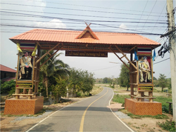
 Gateway over entry road to Ban Fai | |
 | |
| Coordinates: 17°46′11″N 100°43′30″E / 17.769741°N 100.725102°E | |
| Country | Thailand |
| Province | Uttaradit |
| District | Nam Pat District |
| Population (2005) | |
• Total | 7,458 |
| Time zone | UTC+7 (ICT) |
Ban Fai (Thai: บ้านฝาย, pronounced [bâːn fǎːj]) is a village and tambon (sub-district) of Nam Pat District, in Uttaradit Province, Thailand.[1] In 2005, it had a population of 7,458 people. The tambon contains eight villages.
References
[edit]- ^ Thaitambon.com Archived 2010-02-09 at the Wayback Machine, Accessed 16 August 2011 (in Thai)
