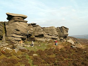
Bamford Edge
Appearance
| Bamford Edge | |
|---|---|
 Climbers on Gun Buttress, Bamford Edge | |
| Location | Peak District, United Kingdom |
| Nearest city | Sheffield |
| Range | Pennines |
| Climbing type | Traditional crag[1] |
| Height | 8 metres (26 ft) to 13 metres (43 ft)[2] |
| Ratings | D to E7[1] |
| Quantity of rock | 150 routes[1] |
| Cliff aspect | South-west[1] |
| Elevation | 400 metres (1,300 ft)[1] |
| Ownership | Private |
| Access | All year (except pre-announced closures)[1] |
Bamford Edge is an overhang of gritstone rock that sticks out north of the village of Bamford, Hope Valley, in the English county of Derbyshire.[3] The first ascent of "Smoked Salmon", which is graded as E8 7b was made by British climber Johnny Dawes.[4]
Bamford Edge has numerous trails across it and, on a clear day, provides views of almost all of the Hope Valley. Some trails come out at New Road opposite the Yorkshire Bridge public house.
References
[edit]- ^ a b c d e f "UKC Databases - "Bamford Edge"". 18 February 2005. Archived from the original on 18 February 2005. Retrieved 16 August 2023.
{{cite web}}: CS1 maint: bot: original URL status unknown (link) - ^ "ROCKFAX %7C Databases %7C Bamford". 11 July 2004. Archived from the original on 11 July 2004. Retrieved 16 August 2023.
{{cite web}}: CS1 maint: bot: original URL status unknown (link) - ^ Ordnance Survey: Landranger map sheet 110 Sheffield & Huddersfield (Glossop & Holmfirth) (Map). Ordnance Survey. 2012. ISBN 9780319231876.
- ^ "ROCKFAX %7C Databases %7C Bamford > Great Tor Lower". 29 August 2003. Archived from the original on 29 August 2003. Retrieved 16 August 2023.
{{cite web}}: CS1 maint: bot: original URL status unknown (link)
External links
[edit]Wikimedia Commons has media related to Bamford Edge.
- Detailed description of climbing the Edge
- Photograph
- Map sources for Bamford Edge
53°21′41″N 1°41′31″W / 53.36148°N 1.69192°W

