Balda Canyon Natural Monument
Appearance
| Balda Canyon Natural Monument | |
|---|---|
| Baldi Canyon Natural Monument | |
 Balda canyon. | |
| Location | |
| Coordinates | 42°29′19.2″N 42°24′34.8″E / 42.488667°N 42.409667°E |
| Area | 0.15 km2 (0.058 sq mi) |
| Established | 2013 |
| Governing body | Agency of Protected Areas |
| Website | Baldi Canyon Natural Monument |
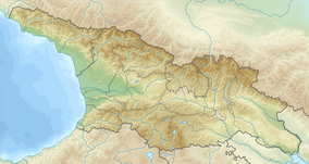
Balda Canyon Natural Monument (Georgian: ბალდის კანიონი) is an Abasha gorge located in Samegrelo region of Western Georgia in Martvili Municipality near village Second Balda and Balda Monastery of St. Mary's Assumption, 295 meters above sea level.[1] Canyon created by limestone rocks in the southern part of the Ashkah massif by the Abasha River. Baldi Canyon is 1400 m long, 5-10 m wide and 25-30 m deep.[2]
See also
[edit]- List of natural monuments of Georgia
- Abasha (river)
- River Abasha Waterfall Natural Monument
- Gachedili Canyon Natural Monument
References
[edit]Wikimedia Commons has media related to Balda Canyon Natural Monument.
- ^ Balda Canyon in Georgia Protected Planet 2014–2019
- ^ (in Georgian) ბალდის კანიონის შესახებ GEORGIAN TRAVEL GUIDE


