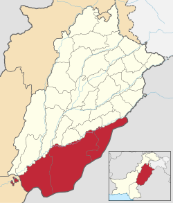
Bahawalpur Division
Appearance
Bahawalpur Division
بہاولپور ڈویژن بہاول پور ڈویژن | |
|---|---|
 Map of Bahawalpur Division | |
| Country | |
| Province | |
| Headquarters | Bahawalpur |
| Government | |
| • Type | Divisional Administration |
| • Commissioner | N/A |
| • Regional Police Officer | N/A |
| Area | |
• Division | 45,588 km2 (17,602 sq mi) |
| Population (2023)[1] | |
• Division | 13,400,009 |
| • Density | 293.94/km2 (761.3/sq mi) |
| • Urban | 3,935,691 (29.37%) |
| • Rural | 9,464,318 |
| Literacy | |
| • Literacy rate |
|
| Website | bahawalpurdivision |
Bahawalpur Division (Punjabi: بہاولپور ڈویژن; Urdu: بہاول پور ڈویژن) is an administrative division of the Punjab Province, Pakistan. The reforms of 2000 abolished the third tier of government but division system was restored again in 2008.[3][4]
List of the Districts
[edit]| # | District[5] | Capital | Area
(km²)[6] |
Pop.
(2023) |
Density
(ppl/km²) (2023)[6] |
Lit.
rate (2023) |
|---|---|---|---|---|---|---|
| 1 | Rahim Yar Khan | Rahim Yar Khan | 11,880 | 5,564,703 | 468.2 | 47.94% |
| 2 | Bahawalnagar | Bahawalnagar | 8,878 | 3,550,342 | 399.6 | 57.01% |
| 3 | Bahawalpur | Bahawalpur | 24,830 | 4,284,964 | 172.3 | 53.35% |
List of the Tehsils
[edit]| # | Tehsil | Area
(km²) |
Pop.
(2023)[6] |
Density
(ppl/km²) (2023)[6] |
Lit. rate
(2023)[6] |
District |
|---|---|---|---|---|---|---|
| 1 | Bahawalnagar | 1,729 | 976,049 | 564.52 | 53.5% | Bahawalnagar |
| 2 | Chishtian | 1,500 | 845,439 | 563.63 | 60.49% | |
| 3 | Fort Abbas | 2,536 | 510,253 | 201.20 | 61.36% | |
| 4 | Haroonabad | 1,295 | 615,476 | 475.27 | 66.28% | |
| 5 | Minchinabad | 1,818 | 603,125 | 331.75 | 44.05% | |
| 6 | Ahmadpur East | 1,738 | 1,307,578 | 752.35 | 39.68% | Bahawalpur |
| 7 | Bahawalpur City | 1,490 | 815,202 | 547.12 | 71.67% | |
| 8 | Bahawalpur Saddar | 745 | 675,950 | 907.32 | 52.56% | |
| 9 | Hasilpur | 1,490 | 508,415 | 341.22 | 59.64% | |
| 10 | Khairpur Tamewali | 993 | 290,582 | 292.63 | 45.82% | |
| 11 | Yazman | 18,374 | 687,237 | 37.40 | 53.55% | |
| 12 | Khanpur | 3,190 | 1,169,138 | 366.50 | 50.08% | Rahim Yar Khan |
| 13 | Liaqatpur | 3,262 | 1,235,264 | 378.68 | 38.35% | |
| 14 | Rahim Yar Khan | 2,464 | 1,778,542 | 721.81 | 53.66% | |
| 15 | Sadiqabad | 2,964 | 1,381,759 | 466.18 | 47.04% |
Demographics
[edit]Population
[edit]| Year | Pop. | ±% p.a. |
|---|---|---|
| 1951 | N/A | — |
| 1961 | N/A | — |
| 1972 | N/A | — |
| 1981 | N/A | — |
| 1998 | N/A | — |
| 2017 | N/A | — |
| 2023 | 13,400,009 | — |
| Sources:[7] | ||
According to the 2023 census, Bahawalpur division has a population of 13,400,009.[8]
Language
[edit]According to 2023 census, Saraiki and Punjabi is the dominate language in the division with 49.1% and 42.60% population respectively.
Religion
[edit]Islam is the predominate religion in the division.
| Religion | Population (1941)[10]: 42 | Percentage (1941) |
|---|---|---|
| Islam |
1,098,814 | 81.93% |
| Hinduism |
174,408 | 13% |
| Sikhism |
46,945 | 1.84% |
| Christianity |
3,048 | 0.23% |
| Jainism | 351 | 0.03% |
| Others [c] | 17,643 | 1.32% |
| Total Population | 1,341,209 | 100% |
See also
[edit]References
[edit]- ^ "DISTRICT WISE CENSUS RESULTS CENSUS 2017" (PDF). www.pbscensus.gov.pk. Archived from the original (PDF) on 2017-08-29.
- ^ "Literacy rate, enrolments, and out-of-school population by sex and rural/urban, CENSUS-2023" (PDF).
- ^ "Division and district-wise facilities" (PDF). health.punjab.gov.pk. Archived from the original (PDF) on 2015-04-16.
- ^ "Punjab Government Plans to Carve a New District from Lahore". Archived from the original on 2010-06-03.
- ^ "Bahawalpur Division | Local Government and Community Development". lgcd.punjab.gov.pk. Retrieved 2022-07-07.
- ^ a b c d e "TABLE 1 : AREA, POPULATION BY SEX, SEX RATIO, POPULATION DENSITY, URBAN POPULATION, HOUSEHOLD SIZE AND ANNUAL GROWTH RATE, CENSUS-2023, PUNJAB" (PDF).
- ^ "Population by administrative units 1951-1998" (PDF). Pakistan Bureau of Statistics.
- ^ https://www.pbs.gov.pk/sites/default/files/population/2023/tables/punjab/pcr/table_1.pdf [bare URL PDF]
- ^ "Population by Mother Tongue, Sex and Rural/Urban, Census-2023" (PDF). Pakistan Bureau of Statistics. 2023. Retrieved 2 Aug 2024.
- ^ "CENSUS OF INDIA, 1941 VOLUME VI PUNJAB PROVINCE". Retrieved 19 August 2022.
- ^ 1941 figures are for the princely state, as the contemporary division borders roughly mirror the historic colonial-era state borders.
- ^ 1941 census: Including Ad-Dharmis
- ^ Including Buddhism, Zoroastrianism, Judaism, or not stated
