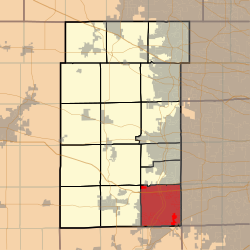
Aurora Township, Illinois
Appearance
Aurora Township | |
|---|---|
 Location in Kane County | |
 Kane County's location in Illinois | |
| Coordinates: 41°46′07″N 088°19′08″W / 41.76861°N 88.31889°W | |
| Country | United States |
| State | Illinois |
| County | Kane |
| Established | November 6, 1849 |
| Area | |
• Total | 35.31 sq mi (91.5 km2) |
| • Land | 34.68 sq mi (89.8 km2) |
| • Water | 0.63 sq mi (1.6 km2) 1.78% |
| Elevation | 689 ft (210 m) |
| Population (2010) | |
• Estimate (2016)[2] | 148,890 |
| • Density | 4,214.6/sq mi (1,627.3/km2) |
| FIPS code | 17-089-03025 |
| GNIS feature ID | 0428621 |
| Website | auroratownship |
Aurora Township is located in Kane County, Illinois. It is divided by the Fox River. As of the 2010 census, its population was 146,149 and it contained 49,127 housing units.[3]
Geography
[edit]According to the 2010 census, the township has a total area of 35.31 square miles (91.5 km2), of which 34.68 square miles (89.8 km2) (or 98.22%) is land and 0.63 square miles (1.6 km2) (or 1.78%) is water.[3]
Cities, towns, villages
[edit]- Aurora (vast majority)
- Montgomery (half)
- North Aurora (mostly)
Unincorporated Towns
[edit]- Marywood at 41°47′37″N 88°17′10″W / 41.793674°N 88.286224°W
- Scraper-Moecherville at 41°44′28″N 88°16′23″W / 41.741135°N 88.273178°W
- South Park at 41°44′00″N 88°17′56″W / 41.73322°N 88.29877°W
Demographics
[edit]| Census | Pop. | Note | %± |
|---|---|---|---|
| 2016 (est.) | 148,890 | [2] | |
| U.S. Decennial Census[4] | |||
School districts
[edit]- East Aurora Public School District 131
- West Aurora Public School District 129
- Batavia Unit School District 101
Government
[edit]The Town Hall is located at 80 N. Broadway, Aurora, Illinois. The Township is led by an elected Supervisor and four Trustees. An Assessor, Clerk and Highway Commissioner are also elected.
The township is responsible for road maintenance, staffing a Youth and Community Center, and operating a handicapped accessible Ride-In-Kane transportation system.
Notes
[edit]- ^ "US Board on Geographic Names". United States Geological Survey. October 25, 2007. Retrieved January 31, 2008.
- ^ a b "Population and Housing Unit Estimates". Retrieved June 9, 2017.
- ^ a b "Population, Housing Units, Area, and Density: 2010 - County -- County Subdivision and Place -- 2010 Census Summary File 1". United States Census. Archived from the original on February 12, 2020. Retrieved May 28, 2013.
- ^ "Census of Population and Housing". Census.gov. Retrieved June 4, 2016.
References
[edit]- "Aurora Township, Kane County, Illinois". Geographic Names Information System. United States Geological Survey, United States Department of the Interior. Retrieved January 17, 2010.
- "ROE Boundary Map" (Map). Kane County Regional Office of Education. August 2017. Retrieved April 22, 2020.
External links
[edit]

