Atlantic dry forests
This article needs additional citations for verification. (August 2024) |
| Atlantic Dry Forests (NT0202) | |
|---|---|
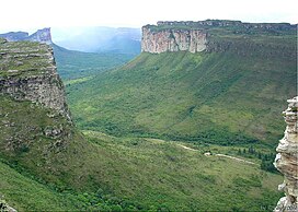
 Dry forest in Chapada Diamantina | |
 Atlantic dry forests localization as delineated by WWF. | |
| Ecology | |
| Biome | Atlantic Forest |
| Borders | |
| Bird species | 311[1] |
| Mammal species | 147[1] |
| Geography | |
| Area | 115,440 km2 (44,570 sq mi) |
| Country | |
| States | |
| Coordinates | 14°S 44°W / 14°S 44°W |
| Conservation | |
| Conservation status | Vulnerable |
| Habitat loss | 70%[2] |
The Atlantic dry forests are a tropical dry forest ecoregion of the Atlantic Forest Biome, located in eastern Brazil.
Setting
[edit]The Atlantic dry forests cover an area of 115,100 square kilometers (44,400 sq mi), lying between the Cerrado savannas of central Brazil and the Caatinga dry shrublands of northeastern Brazil. The Atlantic dry forests stretch from northern Minas Gerais state across western Bahia state into central Piauí. The Atlantic dry forests generally lie along the upper São Francisco River of Minas Gerais and Bahia, and in the basin of the Gurguéia River in Piauí. A large enclave of Atlantic dry forest lies on the Chapada Diamantina of east-central Bahia.
Flora
[edit]The Atlantic dry forests are dense, with deciduous and semi-deciduous trees reaching up to 25 to 30 meters in height. The Barriguda Tree, Cavanillesia arborea, is a dry forest tree species distinguished by its huge, bottle-shaped trunk which reaches up to 1.5 meters in diameter.
Fauna
[edit]This section is empty. You can help by adding to it. (July 2010) |
Conservation and threats
[edit]This section is empty. You can help by adding to it. (July 2010) |
References
[edit]- ^ a b Hoekstra, J. M.; Molnar, J. L.; Jennings, M.; et al. (2010). Molnar, J. L. (ed.). The Atlas of Global Conservation: Changes, Challenges, and Opportunities to Make a Difference. University of California Press. ISBN 978-0-520-26256-0.
- ^ "Atlantic dry forests". Terrestrial Ecoregions. World Wildlife Fund.
External links
[edit]- "Atlantic dry forests". Terrestrial Ecoregions. World Wildlife Fund.
- Atlantic dry forest photos, including Barriguda Tree (World Wildlife Fund)
