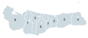
Atlántida Department
Atlántida Department
Departamento de Atlántida | |
|---|---|
 | |
 | |
| Coordinates: 15°38′36″N 87°07′54″W / 15.64333°N 87.13167°W | |
| Country | |
| Municipalities | 8 |
| Villages | 224 |
| Founded | 24 February 1902 |
| Capital city | La Ceiba |
| Government | |
| • Type | Departmental |
| • Gobernador | Noelmy Balbina Arzú Cacho (2018-2022)[1] (PNH) |
| Area | |
• Total | 4,227 km2 (1,632 sq mi) |
| Population (2015)[2] | |
• Total | 449,822 |
| • Density | 110/km2 (280/sq mi) |
| GDP (Nominal, 2015 US dollar) | |
| • Total | $1.5 billion (2023)[3] |
| • Per capita | $2,800 (2023) |
| GDP (PPP, constant 2015 values) | |
| • Total | $2.3 billion (2023) |
| • Per capita | $5,800 (2023) |
| Time zone | UTC-6 (CDT) |
| Postal code | 31101 |
| ISO 3166 code | HN-AT |
| HDI (2021) | 0.627[4] medium · 4th of 18 |
| Statistics derived from Consult INE online database: Population and Housing Census 2013[5] | |
Atlántida (Spanish pronunciation: [aˈtlantiða]) is a department located on the north Caribbean shore of Honduras. The capital is the port city of La Ceiba.
In the past few decades, tourism has become the most important legitimate economic source for the coastal area. In 2005 it had an estimated population of about 372,532 people. The department covers a total surface area of 4,251 km².
History
[edit]
The department was formed in 1902 from territory previously parts of the departments of Colón, Cortés, and Yoro. In 1910 it had a population of about 11,370 people.[citation needed]
Municipalities
[edit] |
Medical care
[edit]Medical care is available at the Jungle Hospital,[6] which is located in the village of Rio Viejo, 20.1 road kilometers south of La Ceiba in the valley of the Rio Cangrejal. From La Ceiba, one should take the Carretera a La Cuenca (V200) to Rio Viejo.
References
[edit]- ^ "Juramentan a gobernadores y comisionados presidenciales de Atlántida, La Paz, Santa Bárbara y Comayagua" [Swearing in of governors and presidential commissioners of Atlántida, La Paz, Santa Bárbara and Comayagua]. Presidencia Honduras (in Spanish). Tegucigalpa. 27 February 2018. Archived from the original on 13 September 2018. Retrieved 2018-09-12.
- ^ "GeoHive - Honduras extended". Retrieved 31 December 2015.
- ^ "TelluBase—Honduras Fact Sheet (Tellusant Public Service Series)" (PDF). Retrieved 2024-01-11.
- ^ "Sub-national HDI - Area Database - Global Data Lab". hdi.globaldatalab.org. Retrieved 2018-09-13.
- ^ "Consulta Base de datos INE en línea: Censo de Población y Vivienda 2013" [Consult INE online database: Population and Housing Census 2013]. Instituto Nacional de Estadística (INE) (in Spanish). El Instituto Nacional de Estadística (INE). 1 August 2018. Retrieved 2018-09-13.
- ^ "Jungle Hospital". Jungle Hospital. Retrieved 31 August 2017.

