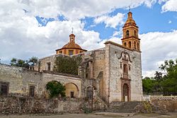
Armadillo de los Infante
Appearance
You can help expand this article with text translated from the corresponding article in Spanish. (March 2015) Click [show] for important translation instructions.
|
Armadillo de los Infante | |
|---|---|
Municipality and town | |
 Templo de La Virgen del Carmen in Pozo del Carmen | |
 | |
| Country | |
| State | San Luis Potosí |
| Time zone | UTC-6 (Central Standard Time) |
| • Summer (DST) | UTC-5 (Central Daylight Time) |
Armadillo de los Infante is a town and municipality in the Mexican state of San Luis Potosí in central Mexico.[1]
Name
[edit]The name of the town is in honor of the Infante family, owners of the first printing company there, in the early nineteenth century.
Geography
[edit]It is located at the center of the state and approximately 61 kilometers from the city of San Luis Potosí.
Climate
[edit]The municipality is semi-warm climate with warm summer rains. The average annual temperature is 18 °C, with a maximum of 27 °C and minimum of 1 °C. The rain is normal between the months of May and August, with an average of 304.7 mm.
Places of interest
[edit]Church of the Immaculate Conception, Printing house, Ex Hacienda Pozo del Carmen, Dam Sweet Vara.
References
[edit]- ^ Enciclopedia de los Municipios de México. Instituto Nacional para el Federalismo y el Desarrollo Municipal https://web.archive.org/web/20070128021947/http://www.e-local.gob.mx/work/templates/enciclo/sanluispotosi/. Archived from the original on January 28, 2007. Retrieved January 11, 2010.
{{cite web}}: Missing or empty|title=(help)
22°15′N 100°39′W / 22.25°N 100.65°W

