Arizona's 2nd congressional district
| Arizona's 2nd congressional district | |
|---|---|
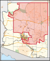
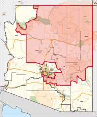
Interactive map of district boundaries since January 3, 2023 | |
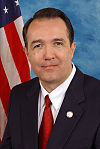
| Representative | |
| Area | 58,970 sq mi (152,700 km2) |
| Distribution |
|
| Population (2023) | 833,298[1] |
| Median household income | $63,735[1] |
| Ethnicity |
|
| Cook PVI | R+6[2] |
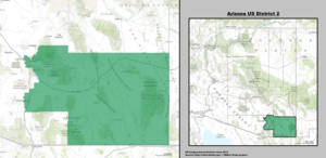
Arizona's 2nd congressional district is a congressional district located in the U.S. state of Arizona. The district is in the north eastern part of the state and includes Apache, Coconino, Gila, Navajo, and Yavapai counties in their entirety and portions of Graham, Maricopa, Mohave, and Pinal counties. The largest city in the district is Flagstaff.
Before January 2023, Arizona's 2nd district was located in the southeastern corner of the state and included Cochise and eastern Pima counties, drawing most of its population from the city of Tucson. The majority of that district was renumbered as the 6th district, while the 2nd was redrawn to essentially take over what was the 1st district from 2003 to 2023.
The district includes 12 Indian reservations including the Hualapai, Havasupai, Hopi, Navajo, San Carlos Apache, and White Mountain Apache peoples. 22% of the district's citizens are Native American.[3]
History
[edit]When Arizona was divided into congressional districts for the first time after the 1950 census, the 2nd district comprised the entire state outside of the Phoenix area. Arizona gained a third seat after the 1960 census, and the 2nd was cut back to roughly the southern third of the state, stretching border-to-border from New Mexico to California. It ran along the entire length of the border with Mexico. By far the district's largest city was Tucson. The next largest city was Yuma, in the far west. After a mid-decade redistricting in 1967, the district was pushed slightly to the north, picking up a portion of southern Phoenix. This configuration remained largely unchanged until the 1980 census, when much of eastern Tucson was drawn into the new 5th district.
The 2nd district remained based in southern Arizona until the 2000 census, when Arizona picked up two districts. At that time, the old 2nd district essentially became the new 7th district, while most of the old 3rd district became the new 2nd district. Located in the northwestern corner of the state, it stretched into the western suburbs of Phoenix, known as the West Valley. It consisted of all of Peoria (within the exception of the portion of that city within Yavapai County) and Surprise, most of Glendale and much of western Phoenix in Maricopa County, all of Mohave County, and the Hopi Nation in Navajo and Coconino counties.
The size and diversity of the 2nd district (it included nearly all of the northwestern portion of the state) made it appear rural on a map. However, over 90 percent of its population lived in the strongly conservative West Valley, historically a fairly safe Republican area.
The odd shape of the district was indicative of the use of gerrymandering in its construction. The unusual division was not, however, drawn to favor politicians, but was due to historic tensions between the Hopi and the Navajo Native American tribes. Since tribal boundary disputes are a federal matter, it was long believed inappropriate to include both tribes' reservations in the same congressional district.[4] However, the Hopi reservation is completely surrounded by the Navajo reservation. In order to comply with current Arizona redistricting laws, some means of connection was required that avoided including large portions of Navajo land, hence the narrow riverine connection.
George W. Bush carried the district in 2004 with 61% of the vote. John McCain won the district in 2008 with 60.75% of the vote to Barack Obama's 38.07%. During the 2008 Super Tuesday Arizona Democratic primary, the district was won by Hillary Clinton with 54.52% of the vote, while Obama received 35.62% and John Edwards took in 7.43%. In the Arizona Republican primary, the 2nd district was won by favorite son McCain with 49.51%, while Mitt Romney received 29.51% and Mike Huckabee took in 10.46% of the district's vote.
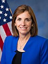
After the 2012 census, the bulk of the Maricopa County portion of the old 2nd became the 8th district, while the new 2nd district took in most of the territory of the old 8th district. That district, in turn, had been the 5th district from 1983 to 2003. In the 2014 midterms, the district was the last U.S. House race in the country to be decided, as the official recount began on December 1 due to Republican Martha McSally leading incumbent Democratic congressman Ron Barber by fewer than 200 votes. Ultimately, Barber lost to McSally by 167 votes.
Main industries
[edit]Primary job fields of the people in the district include agriculture, ranching, livestock, mining, and tourism. The main irrigated crops are cotton, wheat, corn, grain, sorghum, alfalfa, hay, apples, peaches, cherries, grapes, pistachios, pecans, lettuce, chili peppers, and other vegetables. The area has a multitude of U-pick vegetable farms and orchards, including several organic farms. Greenhouse tomato and cucumber operations have been completed in the past few years with much success. In Cochise County there is the U.S. Army base Fort Huachuca and numerous military-industrial companies. In suburban and urban areas, Walmarts are the most abundant superstores.
Schools
[edit]Located within the district are Northern Arizona University, Diné College, Yavapai College, Prescott College, and Embry–Riddle Aeronautical University.
Tourism and recreation
[edit]Tourism is an important industry as the district has numerous natural wonders, national forests, parks, and conservation areas. Grand Canyon and Petrified Forest National Parks highlight the public lands in the district. Other prominent tourist attractions include Lake Powell, Sedona, Meteor Crater , and the self-proclaimed "World's Oldest Rodeo". Hiking, camping, fishing, and boating can be found throughout the region.
The Apache-Sitgraves, Coconino, Kaibab, Prescott, and Tonto National forests are most or partially in the 2nd district. The sacred Oak Flat site is also within the district.
Composition
[edit]| # | County | Seat | Population |
|---|---|---|---|
| 1 | Apache | St. Johns | 65,036 |
| 5 | Coconino | Flagstaff | 144,472 |
| 7 | Gila | Globe | 54,003 |
| 9 | Graham | Safford | 39,525 |
| 13 | Maricopa | Phoenix | 4,585,871 |
| 15 | Mohave | Kingman | 223,682 |
| 17 | Navajo | Holbrook | 109,175 |
| 21 | Pinal | Florence | 484,239 |
| 25 | Yavapai | Prescott | 249,081 |
Cities of 10,000 people or more
[edit]- Flagstaff – 76,831
- Maricopa – 66,290
- Casa Grande – 53,659
- Prescott Valley – 46,785
- Prescott – 45,827
- Florence – 26,785
- Payson – 16,361
- Coolidge – 13,218
- Chino Valley – 13,020
- Camp Verde – 12,147
- Cottonwood – 12,029
- Verde Village – 12,019
- Show Low – 11,732
- Gold Canyon – 11,404
2,500 – 10,000 people
[edit]- Sedona – 9,684
- Winslow – 9,005
- Tuba City – 8,072
- Wickenburg – 7,474
- Page – 7,440
- Globe – 7,249
- Williamson – 6,196
- Village of Oak Creek – 6,128
- Snowflake – 6,104
- Paulden – 5,567
- Lake Montezuma – 5,111
- Holbrook – 4,858
- Kayenta – 4,670
- Chinle – 4,573
- Whiteriver – 4,520
- Clarkdale – 4,424
- Eagar – 4,395
- Dewey-Humboldt – 4,326
- Pinetop–Lakeside – 4,030
- Taylor – 3,995
- San Carlos – 3,987
- Doney Park – 3,894
- Lake of the Woods – 3,648
- Fort Defiance – 3,541
- St. Johns – 3,417
- Cornville – 3,362
- Sacaton – 3,254
- Williams – 3,202
- Heber-Overgaard – 2,898
- Cordes Lakes – 2,684
- Black Canyon City – 2,677
- Linden – 2,597
- Timberline-Fernwood – 2,572
- Kachina Village – 2,502
- Window Rock – 2,500
Voting
[edit]| Election results from presidential races | ||
|---|---|---|
| Year | Office | Results |
| 2000 | President | Gore 56 - 41% |
| 2004 | President | Bush 61 - 38% |
| 2008 | President | McCain 61 - 38% |
| 2012 | President | Romney 50 - 48% |
| 2016 | President | Clinton 50 - 45% |
| 2020 | President | Biden 55 - 44% |
List of members representing the district
[edit]Starting with the 1948 elections, Arizona began using separate districts to elect its members to the House of Representatives rather than using a general ticket due to having gained a second seat in the House with the data from 1940 Census.
Recent election results
[edit]2002
[edit]| Party | Candidate | Votes | % | ±% | |
|---|---|---|---|---|---|
| Republican | Trent Franks | 100,359 | 59.92% | ||
| Democratic | Randy Camacho | 61,217 | 36.55% | ||
| Libertarian | Edward Carlson | 5,919 | 3.53% | ||
| Majority | 39,142 | 23.37% | |||
| Total votes | 167,502 | 100.00 | |||
| Republican hold | |||||
2004
[edit]| Party | Candidate | Votes | % | ±% | |
|---|---|---|---|---|---|
| Republican | Trent Franks* (incumbent) | 165,260 | 59.17% | ||
| Democratic | Randy Camacho | 107,406 | 38.46% | ||
| Libertarian | Powell Gammill | 6,625 | 2.37% | ||
| Majority | 57,854 | 20.71% | |||
| Total votes | 279,303 | 100.00 | |||
| Republican hold | |||||
2006
[edit]| Party | Candidate | Votes | % | ±% | |
|---|---|---|---|---|---|
| Republican | Trent Franks* (incumbent) | 135,150 | 58.62% | ||
| Democratic | John Thrasher | 89,671 | 38.89% | ||
| Libertarian | Powell Gammill | 5,734 | 2.49% | ||
| Majority | 45,479 | 19.73% | |||
| Total votes | 230,560 | 100.00 | |||
| Republican hold | |||||
2008
[edit]| Party | Candidate | Votes | % | ±% | |
|---|---|---|---|---|---|
| Republican | Trent Franks* (incumbent) | 200,914 | 59.44% | ||
| Democratic | John Thrasher | 125,611 | 37.16% | ||
| Libertarian | Powell Gammill | 7,882 | 2.33% | ||
| Green | William Crum | 3,616 | 1.07% | ||
| Majority | 75,303 | 22.28% | |||
| Total votes | 338,023 | 100.00 | |||
| Republican hold | |||||
2010
[edit]| Party | Candidate | Votes | % | ±% | |
|---|---|---|---|---|---|
| Republican | Trent Franks* (incumbent) | 173,173 | 64.89% | ||
| Democratic | John Thrasher | 82,891 | 31.06% | ||
| Libertarian | Powell Gammill | 10,820 | 4.05% | ||
| Majority | 90,282 | 33.83% | |||
| Total votes | 266,884 | 100.00 | |||
| Republican hold | |||||
2012
[edit]| Party | Candidate | Votes | % | ±% | |
|---|---|---|---|---|---|
| Democratic | Ron Barber* | 147,338 | 50.41% | ||
| Republican | Martha McSally | 144,884 | 49.57% | ||
| Write-In | Write-ins | 57 | 0.02% | ||
| Majority | 2,454 | 0.84% | |||
| Total votes | 292,279 | 100.00 | |||
| Democratic gain from Republican | |||||
2014
[edit]| Party | Candidate | Votes | % | ±% | |
|---|---|---|---|---|---|
| Republican | Martha McSally | 109,704 | 49.81% | ||
| Democratic | Ron Barber* (incumbent) | 109,583 | 49.75% | ||
| Write-In | Write-ins | 1,007 | 0.46% | ||
| Majority | 121 | 0.06% | |||
| Total votes | 220,254 | 100.00% | |||
| Republican gain from Democratic | |||||
2016
[edit]| Party | Candidate | Votes | % | ±% | |
|---|---|---|---|---|---|
| Republican | Martha McSally* (incumbent) | 179,806 | 56.96% | ||
| Democratic | Matt Heinz | 135,873 | 43.04% | ||
| Majority | 43,933 | 13.92% | |||
| Total votes | 315,679 | 100% | |||
| Republican hold | |||||
2018
[edit]| Party | Candidate | Votes | % | ±% | |
|---|---|---|---|---|---|
| Democratic | Ann Kirkpatrick | 161,000 | 54.73% | +11.69% | |
| Republican | Lea Márquez Peterson | 133,083 | 45.24% | −11.72% | |
| Margin of victory | 27,917 | 9.49% | +23.41% | ||
| Total votes | 294,083 | 100.0% | N/A | ||
| Democratic gain from Republican | |||||
2020
[edit]| Party | Candidate | Votes | % | |
|---|---|---|---|---|
| Democratic | Ann Kirkpatrick* (incumbent) | 209,945 | 55.1% | |
| Republican | Brandon Martin | 170,975 | 44.9 | |
| Write-In | Write-ins | 134 | 0.0 | |
| Total votes | 381,054 | 100.0 | ||
| Democratic hold | ||||
2022
[edit]| Party | Candidate | Votes | % | |||
|---|---|---|---|---|---|---|
| Republican | Eli Crane | 174,169 | 53.9 | |||
| Democratic | Tom O'Halleran (incumbent) | 149,151 | 46.1 | |||
| Independent | Chris Sarappo (write-in) | 76 | 0.0 | |||
| Total votes | 323,396 | 100.0 | ||||
| Republican gain from Democratic | ||||||
See also
[edit]References
[edit]- ^ a b "My Congressional District". www.census.gov. US Census Bureau. Retrieved September 21, 2024.
- ^ "2022 Cook PVI: District Map and List". Cook Political Report. Retrieved January 10, 2023.
- ^ https://redistricting-irc-az.hub.arcgis.com/pages/final-draft-maps#finalcddraftmaps
- ^ Pitzi, Mary Jo, 2011. Navajos seek tribal-dominated district in Arizona. Arizona Republic, Published September 16, 2011. Retrieved November 3, 2011.
- ^ Martis, Kenneth C. (1982). The Historical Atlas of United States Congressional Districts, 1789-1983. New York: Macmillan Publishing.
- ^ Martis, Kenneth C. (1989). The Historical Atlas of Political Parties in the United States Congress, 1789-1989. New York: Macmillan Publishing.
- ^ Congressional Directory: Browse 105th Congress Archived February 17, 2011, at the Wayback Machine
- ^ "2018 General Election". Arizona Secretary of State. November 15, 2018.
External links
[edit]- Maps of Congressional Districts first in effect for the 2002 election
- Tentative Final Congressional Maps for the 2012 election
- Demographic data from census.gov
- 2004 Election data from CNN.com
- 2002 Election data from CBSNews.com
- 2000 Election data from CNN.com
- 1998 Election data from CNN.com
- full listing of candidates, via Arizona Secretary of State's office
- Rose Institute of State and Local Government, "Arizona: 2010 Redistricting Changes: Second District", Redistricting by State, Claremont, CA: Claremont McKenna College, archived from the original on September 15, 2020

