Api (mountain)
| Api | |
|---|---|
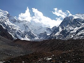
 Approached from the Mahakali Khola, the southern/western aspects of Api. | |
| Highest point | |
| Elevation | 7,132 m (23,399 ft)[1][2] |
| Prominence | 2,040 m (6,690 ft)[1] |
| Listing | Ultras |
| Coordinates | 30°00′15″N 80°56′00″E / 30.00417°N 80.93333°E |
| Geography | |
| Country | Nepal |
| District | Darchula District |
| Parent range | Yoka Pahar Subsection, Gurans Himal, Himalayas |
| Climbing | |
| First ascent | 10 May 1960 by K. Hirabayashi, Gyaltsen Norbu |
| Easiest route | rock/snow/ice climb |

Api is the highest peak in the Yoka Pahar Section of Gurans Himal, part of the Himalayas in the extreme northwest corner of Nepal, near the border with Tibet.[3][failed verification] It is a little-known peak in a rarely visited part of the Himalayas, but it rises dramatically over the low surrounding terrain.[citation needed]
Notable features
[edit]Although low in elevation among the major mountains of Nepal, Api is exceptional in its rise above local terrain; the surrounding valleys are significantly lower than those surrounding most higher Himalayan peaks.[4][failed verification]
Api peak's south face rises 3,300 metres (10,830 ft) above its base.[5]
Climbing history
[edit]
The Api region was visited by Westerners in 1899, 1905 and 1936, but the peak was not attempted until 1953 on a visit by W. H. Murray a Scottish Mountaineer with John Tyson. This attempt was unsuccessful, as was another, by Italians, in 1954 which resulted in the death of two expedition members.[6]
The first ascent of Api occurred in 1960. The Doshisha Alpine Society of Japan successfully completed the Northwest Face route attempted by the 1954 party.[6][7]
In 1980, a British Army Mountaineering Association expedition made an attempt to climb the peak by the south face reaching within a few hundred metres of the summit.[5]
On 24 December 1983, Polish climbers Tadeusz Piotrowski and Andrzej Bieluń made the first winter ascent. Bieluń had reached the summit first alone but did not return to camp.[7]
The Himalayan Index lists three more ascents of the peak, in 1978, 1996, and 2001.[2]
References
[edit]- ^ a b "Ultra-prominent peaks of Nepal". peaklist.org. Archived from the original on 25 December 2008. Retrieved 6 January 2009.
- ^ a b "Himalayan Index". Alpine Club. Retrieved 2009-12-24.
- ^ Carter, H. Adams (1986). "Classification of the Himalaya". The Himalayan Journal. 42. The Himalayan Club. Retrieved 17 April 2019.
- ^ "DEM files for the Himalaya (Corrected versions of SRTM data)". viewfinderpanoramas.org. Archived from the original on 10 December 2009. Retrieved 24 December 2009.
- ^ a b Agnew, Crispin (1981). "Soldiers on Api" (PDF). Alpine Journal: 167–171. Retrieved 17 April 2019.
- ^ a b Neate, Jill (January 1990). High Asia: An Illustrated History of the 7000 Metre Peaks. Mountaineers Books. ISBN 0-89886-238-8.
- ^ a b "Api, Winter Ascent and Tragedy". Climbs and Expeditions, 1983. American Alpine Journal. American Alpine Club: 262–263. 1984. Retrieved 15 June 2020.


