Ansonia, Pennsylvania
Appearance
Ansonia, Pennsylvania | |
|---|---|
Unincorporated community | |
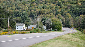
 Scattered houses in Ansonia, along Route 6 | |
| Coordinates: 41°44′47″N 77°25′42″W / 41.74639°N 77.42833°W | |
| Country | United States |
| State | Pennsylvania |
| County | Tioga |
| Elevation | 1,138 ft (347 m) |
| Time zone | UTC-5 (Eastern (EST)) |
| • Summer (DST) | UTC-4 (EDT) |
| ZIP | 16901 |
| Area code | 570 |
| GNIS feature ID | 1202981 [1] |
Ansonia is an unincorporated community in Shippen Township, Tioga County, in the U.S. state of Pennsylvania. It lies along U.S. Route 6, near its junction with Pennsylvania Route 362, between Galeton and Wellsboro.[2]
Ansonia is at the confluence of Marsh Creek and Pine Creek.[3] The Pine Creek Rail Trail passes through Ansonia, where there is an access area.[4]
References
[edit]- ^ a b "Ansonia". Geographic Names Information System. United States Geological Survey, United States Department of the Interior. August 2, 1979. Retrieved September 16, 2012.
- ^ Pennsylvania Atlas & Gazetteer. Yarmouth, Maine: DeLorme. 2009. p. 25. ISBN 978-0-89933-280-2.
- ^ United States Geological Survey. "United States Topographic Map". TopoQuest. Retrieved September 16, 2012..
- ^ "Pine Creek Rail Trail Map" (PDF). Tioga County Visitors Bureau. Archived from the original (PDF) on March 24, 2012. Retrieved September 16, 2012.


