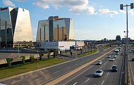
Anjou, Quebec
Anjou | |
|---|---|
 | |
 Anjou's location in Montreal | |
| Coordinates: 45°36′24″N 73°33′20″W / 45.60667°N 73.55556°W | |
| Country | |
| Province | |
| City | Montreal |
| Region | Montréal |
| Established | February 23, 1956 |
| Merged into Montreal | January 1, 2002 |
| Electoral Districts Federal | Honoré-Mercier |
| Provincial | Anjou–Louis-Riel |
| Government | |
| • Type | Borough |
| • Mayor | Luis Miranda |
| • Federal MP(s) | Pablo Rodríguez (LPC) |
| • Quebec MNA(s) | Karine Boivin Roy (CAQ) |
| Area | |
| • Land | 13.7 km2 (5.3 sq mi) |
| Population | |
| • Total | 42,796 |
| • Density | 3,128.4/km2 (8,103/sq mi) |
| • Dwellings | 18,810 |
| Time zone | UTC−5 (Eastern (EST)) |
| • Summer (DST) | UTC−4 (EDT) |
| Postal code(s) | |
| Area codes | (514) and (438) |
| Access Routes[5] | |
| Website | www.ville.montreal.qc.ca/anjou |
Anjou (French pronunciation: [ɑ̃ʒu]) is a borough (arrondissement) of the Canadian city of Montreal. Prior to its 2002 merger it was an independent city. Although it is no longer an independent city, it is still commonly known as known as Ville d'Anjou. Anjou has a predominantly Francophone population.[6]
Geography
[edit]The borough is located in the eastern end of the island of Montreal. The borough largely retained its former municipality logo, although the borough's logo is used on fleet vehicles without Montreal's logo. On fleet vehicles, the text reads "Ville de Montréal, arrondissement Anjou."
The borough is bordered to the north and east by Rivière-des-Prairies–Pointe-aux-Trembles, to the south by Mercier—Hochelaga-Maisonneuve and Montréal-Est, to the west by Saint-Léonard, and at the northwestern corner by Montréal-Nord.
It has an area of 13.7 km2 and a population of nearly 42,796.
Features
[edit]The borough is traversed by Autoroute 40 (Metropolitan Aut.) exits 80 and 82 located within its borders. Exits 6,7,8, (9 and 10 Northbound only) of Autoroute 25 (Louis-Hippolyte La Fontaine Aut.) are also located in Anjou. Among other attractions, it contains the large Les Galeries d'Anjou shopping mall which is one of the few mega malls located within the city of Montreal. The Blue line extension of the Montreal Metro which is expected to be completed in 2029 will have one new station located in Anjou with two entrances located on both sides of Autoroute 25.[7]
Federal and provincial elections
[edit]The entire borough is located within the federal riding of Honoré-Mercier, and within the provincial electoral district of Anjou–Louis-Riel. It is represented in the House of Commons by Pablo Rodriguez of the Liberal Party and in the National Assembly by Karine Boivin Roy of Coalition Avenir Québec.
Borough council
[edit]Following the 2021 Montreal municipal election, the current borough council consists of the following councilors:[8]
| District | Position | Name | Party | |
|---|---|---|---|---|
| — | Borough mayor City councillor |
Luis Miranda | Équipe Anjou | |
| — | City councillor | Andrée Hénault | Équipe Anjou | |
| Centre | Borough councillor | Kristine Marsolais | Équipe Anjou | |
| East | Borough councillor | Richard Leblanc | Équipe Anjou | |
| West | Borough councillor | Marie Josée Dubé | Équipe Anjou |
Demographics
[edit]| Year | Pop. | ±% |
|---|---|---|
| 1966 | 22,477 | — |
| 1971 | 33,885 | +50.8% |
| 1976 | 36,596 | +8.0% |
| 1981 | 37,346 | +2.0% |
| 1986 | 36,916 | −1.2% |
| 1991 | 37,210 | +0.8% |
| 1996 | 37,308 | +0.3% |
| 2001 | 38,015 | +1.9% |
| 2006 | 40,891 | +7.6% |
| 2011 | 41,928 | +2.5% |
| 2016 | 42,796 | +2.1% |
| Language | Population | Percentage (%) |
|---|---|---|
| French | 28,825 | 76% |
| English | 2,905 | 8% |
| Other languages | 6,280 | 16% |
| Language | Population | Percentage (%) |
|---|---|---|
| French | 25,555 | 63% |
| English | 1,630 | 4% |
| Other languages | 13,220 | 33% |
| Ethnicity | Population | Percentage (%) |
|---|---|---|
| Not a visible minority | 28,410 | 68.1% |
| Visible minorities | 13,300 | 31.9% |
Education
[edit]
The Centre de Service Scolaire de la Pointe-de-l'Île operates French-language public schools. The secondary school is the École secondaire d'Anjou.[9]
Primary schools[10]
- Albatros
- Cardinal-Léger
- Chénier
- Des Roseraies
- Jacques-Rousseau
- St-Joseph
- Wilfrid-Pelletier
The English Montreal School Board operates Anglophone public schools:
- Dalkeith Elementary School[11]
The borough has two libraries of the Montreal Public Libraries Network: Haut-Anjou and Jean-Corbeil.[12]
See also
[edit]References
[edit]- ^ "Ministère des Affaires Municipales et Régions: Anjou". Archived from the original on 2013-01-06. Retrieved 2012-03-14.
- ^ Parliament of Canada Federal Riding History: HONORÉ-MERCIER (Quebec)
- ^ Chief Electoral Officer of Québec - 40th General Election Riding Results: ANJOU[permanent dead link]
- ^ a b c d "Arrondissement d'Anjou" (PDF). Sociodemographic Profile 2016 Census (in French). City of Montreal. May 2018. Archived from the original (PDF) on July 25, 2023.
- ^ Official Transport Quebec Road Map
- ^ Wellington, T. A. (2015-07-13). "My Montreal: Anjou & Other Quebec Curios". montrealrampage.com. Retrieved 2023-07-01.
- ^ "Blue line extension". Société de transport de Montréal. Retrieved 2023-01-02.
- ^ "Résultats détaillés pour chacun des postes électifs". Élections Montréal. November 8, 2011. Retrieved November 8, 2021.
- ^ "Secondaire Archived 2015-03-31 at archive.today." Commission scolaire de la Pointe-de-l'Île. Retrieved on December 8, 2014.
- ^ "Primaire Archived 2015-03-31 at archive.today." Commission scolaire de la Pointe-de-l'Île. Retrieved on December 8, 2014.
- ^ "Dalkeith".
- ^ "Les bibliothèques par arrondissement." Montreal Public Libraries Network. Retrieved on December 7, 2014.

