Andimeshk County
Andimeshk County
Persian: شهرستان اندیمشک | |
|---|---|
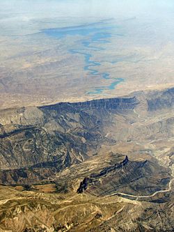
 Dez Reservoir | |
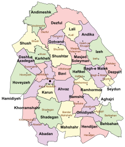
 Location of Andimeshk County in Khuzestan province (top left, green) | |
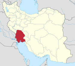
 Location of Khuzestan province in Iran | |
| Coordinates: 32°42′N 48°23′E / 32.700°N 48.383°E[1] | |
| Country | Iran |
| Province | Khuzestan |
| Capital | Andimeshk |
| Districts | Central, Alvar-e Garmsiri |
| Population (2016)[2] | |
• Total | 171,412 |
| Time zone | UTC+3:30 (IRST) |
| Andimeshk County can be found at GEOnet Names Server, at this link, by opening the Advanced Search box, entering "9206380" in the "Unique Feature Id" form, and clicking on "Search Database". | |
Andimeshk County (Persian: شهرستان اندیمشک)[a] is in Khuzestan province, Iran. Its capital is the city of Andimeshk.[3]
History
[edit]After the 2011 National Census, the village of Shahrak-e Babak was elevated to the status of the city of Azadi, five villages merged to form the new city of Bidrubeh, and the village of Cham Golak rose to city status.[4]
Demographics
[edit]Population
[edit]At the time of the 2006 census, the county's population was 154,081 in 33,159 households.[5] The following census in 2011 counted 167,126 people in 42,284 households.[6] The 2016 census measured the population of the county as 171,412 in 48,636 households.[2]
Administrative divisions
[edit]Andimeshk County's population history and administrative structure over three consecutive censuses are shown in the following table.
| Administrative Divisions | 2006[5] | 2011[6] | 2016[2] |
|---|---|---|---|
| Central District | 134,916 | 146,650 | 155,816 |
| Howmeh RD | 15,494 | 19,839 | 10,297 |
| Andimeshk (city) | 119,422 | 126,811 | 135,116 |
| Azadi (city)[b] | 4,957 | ||
| Cham Golak (city) | 5,446 | ||
| Alvar-e Garmsiri District | 19,165 | 17,109 | 14,793 |
| Hoseyniyeh RD | 5,120 | 5,129 | 2,192 |
| Mazu RD | 4,117 | 3,346 | 3,019 |
| Qilab RD | 8,065 | 6,671 | 5,375 |
| Bidrubeh (city)[c] | 2,386 | ||
| Hoseyniyeh (city) | 1,863 | 1,963 | 1,821 |
| Total | 154,081 | 167,126 | 171,412 |
| RD = Rural District | |||
See also
[edit]![]() Media related to Andimeshk County at Wikimedia Commons
Media related to Andimeshk County at Wikimedia Commons
Notes
[edit]References
[edit]- ^ OpenStreetMap contributors (24 July 2023). "Andimeshk County" (Map). OpenStreetMap (in Persian). Retrieved 24 July 2023.
- ^ a b c "Census of the Islamic Republic of Iran, 1395 (2016)". AMAR (in Persian). The Statistical Center of Iran. p. 06. Archived from the original (Excel) on 21 October 2020. Retrieved 19 December 2022.
- ^ Habibi, Hassan. "Approval of the organization and chain of citizenship of the elements and units of the national divisions of Khuzestan province, centered in the city of Ahvaz". Islamic Parliament Research Center (in Persian). Ministry of Interior, Political and Defense Commission of the Government Board. Archived from the original on 17 July 2014. Retrieved 25 January 2024.
- ^ a b c Rahimi, Mohammadreza (19 July 2013). "Carrying out reforms of country divisions in Khuzestan province". Qavanin (in Persian). Ministry of Interior, Political and Defense Commission. Archived from the original on 24 July 2023. Retrieved 24 July 2023.
- ^ a b "Census of the Islamic Republic of Iran, 1385 (2006)". AMAR (in Persian). The Statistical Center of Iran. p. 06. Archived from the original (Excel) on 20 September 2011. Retrieved 25 September 2022.
- ^ a b "Census of the Islamic Republic of Iran, 1390 (2011)". Syracuse University (in Persian). The Statistical Center of Iran. p. 06. Archived from the original (Excel) on 18 January 2023. Retrieved 19 December 2022.
External links
[edit] Media related to Andimeshk County at Wikimedia Commons

