Almaden, Queensland
| Almaden Queensland | |||||||||||||||
|---|---|---|---|---|---|---|---|---|---|---|---|---|---|---|---|
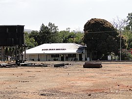
 Railway Hotel at Almaden | |||||||||||||||
| Coordinates | 17°20′26″S 144°40′37″E / 17.3406°S 144.6769°E | ||||||||||||||
| Population | 41 (2021 census)[1] | ||||||||||||||
| • Density | 0.0514/km2 (0.1331/sq mi) | ||||||||||||||
| Postcode(s) | 4871 | ||||||||||||||
| Area | 797.6 km2 (308.0 sq mi) | ||||||||||||||
| Time zone | AEST (UTC+10:00) | ||||||||||||||
| Location | |||||||||||||||
| LGA(s) | Shire of Mareeba | ||||||||||||||
| State electorate(s) | |||||||||||||||
| Federal division(s) | Kennedy | ||||||||||||||
| |||||||||||||||
Almaden is a rural town and locality in the Shire of Mareeba, Queensland, Australia.[2][3] In the 2021 census, the locality of Almaden had a population of 41 people.[1]
Geography
[edit]
Almaden is on the Mareeba-to-Chillagoe railway line (part of the Tablelands railway line) which runs between Mareeba and the mining and cattle town of Mungana. Almaden railway station serves the town (17°20′18″S 144°40′41″E / 17.3384°S 144.6780°E).[4] The Etheridge railway line branches off at Almdaden towards Forsayth, with Ootann railway station, in the south of the locality of Almaden (17°25′59″S 144°38′19″E / 17.4331°S 144.6385°E).[4]
The Burke Developmental Road passes through from east to north-west. Ootann Road exits to the south. [5]
History
[edit]The town is named after the town of Almadén in Cuidad Real Province, Spain, which is known for its mercury mine. The mineral deposits in Queensland's Almaden are tripolite (diatomite).[3]
Tate Tin Mines Provisional School opened on 17 October 1894. On 1 January 1909 it became Tate Tin Mines State School. It closed on 31 Jan 1924 but reopened on 3 February 1930. It closed permanently on 31 December 1940.[6]
Almaden Provisional School opened on 6 July 1906 on a 5-acre (2.0 ha) site.[7][8][9] On 1 January 1909 it became Almaden State School. It closed on 12 December 1997.[6][10] It was at 22 Almaden Second Street (17°20′32″S 144°40′44″E / 17.3421°S 144.6789°E). It is now a tourist park.[11][12]
Ootann Provisional School opened on 23 May 1929 and closed circa 1933.[6]
Demographics
[edit]In the 2016 census, the locality of Almaden had a population of 71 people.[13]
In the 2021 census, the locality of Almaden had a population of 41 people.[1]
Education
[edit]There are no schools in Almaden. The nearest government primary school is Chillagoe State School in neighbouring Chillagoe to the north-west. The nearest secondary school is Dimbulah State School (to Year 10) in Dimbulah to the north-west. For secondary education to Year 12, the options are distance education and boarding schools.[14]
Attractions
[edit]The town is an overnight stop for the Savannahlander which operates twice weekly between Cairns and Forsayth.[15]
References
[edit]- ^ a b c Australian Bureau of Statistics (28 June 2022). "Almaden (SAL)". 2021 Census QuickStats. Retrieved 28 February 2023.
- ^ "Almaden – town in Shire of Mareeba (entry 447)". Queensland Place Names. Queensland Government. Retrieved 28 December 2020.
- ^ a b "Almaden – locality in Shire of Mareeba (entry 48494)". Queensland Place Names. Queensland Government. Retrieved 28 December 2020.
- ^ a b "Railway stations and sidings - Queensland". Queensland Open Data. Queensland Government. 2 October 2020. Archived from the original on 5 October 2020. Retrieved 5 October 2020.
- ^ Almaden, Queensland (Map). OpenStreetMap. Archived from the original on 17 April 2022. Retrieved 13 April 2022.
- ^ a b c Queensland Family History Society (2010), Queensland schools past and present (Version 1.01 ed.), Queensland Family History Society, ISBN 978-1-921171-26-0
- ^ "TELEGRAMS". Morning Post (Cairns). Vol. 19, no. 330. Queensland, Australia. 19 January 1906. p. 2. Archived from the original on 30 April 2022. Retrieved 30 April 2022 – via National Library of Australia.
- ^ "CHILLAGOE NOTES". Morning Post (Cairns). Vol. 19, no. 347. Queensland, Australia. 8 February 1906. p. 4. Archived from the original on 30 April 2022. Retrieved 30 April 2022 – via National Library of Australia.
- ^ "RURAL INTERESTS". The Brisbane Courier. Vol. LXII, no. 15, 103. Queensland, Australia. 8 June 1906. p. 2. Archived from the original on 30 April 2022. Retrieved 30 April 2022 – via National Library of Australia.
- ^ "Queensland state school - centre closures" (PDF). Queensland Government. 20 August 2013. Archived (PDF) from the original on 20 March 2022. Retrieved 7 April 2022.
- ^ "Accommodation Feature – Tamarind Gardens, Almaden". Archived from the original on 6 March 2021. Retrieved 30 April 2022.
- ^ "22 Almaden Street, Almaden QLD 4871". Allhomes. Archived from the original on 30 April 2022. Retrieved 30 April 2022.
- ^ Australian Bureau of Statistics (27 June 2017). "Almaden (SSC)". 2016 Census QuickStats. Retrieved 20 October 2018.
- ^ "Queensland Globe". State of Queensland. Retrieved 26 March 2021.
- ^ "Savannahlander Itinerary". Archived from the original on 13 November 2019. Retrieved 13 November 2019.
External links
[edit]![]() Media related to Almaden, Queensland at Wikimedia Commons
Media related to Almaden, Queensland at Wikimedia Commons

