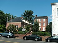
Alexandria Historic District
Alexandria Historic District | |
 Old Dominion Bank Building in Old Town, now "The Athenaeum", an art gallery | |
| Location | Alexandria, Virginia |
|---|---|
| Coordinates | 38°48′12″N 77°2′47″W / 38.80333°N 77.04639°W |
| Built | 1748 |
| Architect | Multiple |
| Architectural style | Colonial, Late Victorian, Federal |
| NRHP reference No. | 66000928 |
| VLR No. | 100-0121 |
| Significant dates | |
| Added to NRHP | November 13, 1966[2] |
| Designated NHLD | November 13, 1966[3] |
| Designated VLR | November 5, 1968[1] |
The Alexandria Historic District is a National Historic Landmark District in Alexandria, Virginia. Encompassing all of the city's Old Town and some adjacent areas, this area contains one of the nation's best-preserved assemblages of the late-18th and early-19th century urban architecture. The district was locally designated (as the Old and Historic Alexandria district) in 1946[4] and was declared a National Historic Landmark in 1966.[3][5][6][7]
History
[edit]The city of Alexandria was chartered in 1748, and its city center was laid out as a grid of streets on the west bank of the Potomac River. One of the surveyors involved in this work was future United States President George Washington. The city grew to become a major seaport serving much of northern Virginia, and its streets were lined with Federal style townhouses. The city remained a major port, dealing principally in grain and tobacco, until the American Civil War. Elements of its historic importance as a port continues in the survival of several waterfront warehouses from that period.[5]
Other National Historic Landmarks within the district include:
Other National Register-listed properties within the district include:
The district boundaries, as defined by the National Register and the Virginia Landmarks Register, are the Potomac River to the east, Queen Street to the north, Jones Point and the Capital Beltway to the south, and Alfred Street to the west. There are a few extensions beyond these bounds, notably along Washington Street as far north as 2nd Street.[5] The commercial center of the district is around S. Washington Street and King Street. Notable buildings in that area include the Art Deco Virginia Public Service building at 117 S. Washington Street, the Post Office and Courthouse at 200 S. Washington Street, and the Burke and Herbert Bank at 621 King Street.[7] Within this larger district is a smaller historic district as defined by the National Historic Landmark designation, consisting of the central portion of the larger district.[8]
Gallery
[edit]-
515 North Washington Street (1848)
-
Burke & Herbert Bank at 621 King Street (1906)
-
117 S. Washington St. (c.1930s)
-
The Alexandria Academy
-
Roundel used to designate a historic building in Alexandria
See also
[edit]- List of National Historic Landmarks in Virginia
- National Register of Historic Places listings in Alexandria, Virginia
References
[edit]- ^ "Virginia Landmarks Register". Virginia Department of Historic Resources. Archived from the original on September 21, 2013. Retrieved March 19, 2013.
- ^ "National Register Information System". National Register of Historic Places. National Park Service. March 13, 2009.
- ^ a b "Alexandria Historic District". National Historic Landmark summary listing. National Park Service. Archived from the original on January 1, 2008. Retrieved February 18, 2008.
- ^ Department of Historic Resoruces, "Historic Districts in Virginia", 2014, p. 7
- ^ a b c Edward P. Alexander (March 28, 1969), National Register of Historic Places Inventory-Nomination: Alexandria (PDF), National Park Service, archived from the original (pdf) on May 12, 2008
- ^ National Register of Historic Places Inventory-Nomination: Addendum, Alexandria Historic District, Alexandria, Virginia (pdf), National Park Service, October 31, 1984
- ^ a b Itemization of properties included in Alexandria Historic District, Alexandria, Virginia (PDF), Virginia DHR, November 27, 2001, archived from the original (pdf) on January 16, 2009
- ^ "Alexandria's Listed Historic Districts" Virginia Department of Historic Resources
External links
[edit]- 100-0121 Alexandria Historic District from Virginia Department of Historic Resources
- Map of Alexandria Historic District from Virginia Department of Historic Resources
- Historic districts in Alexandria, Virginia
- History of Alexandria, Virginia
- Historic districts on the National Register of Historic Places in Virginia
- National Historic Landmarks in Virginia
- National Register of Historic Places in Alexandria, Virginia
- Federal architecture in Virginia
- Georgian architecture in Virginia
- Greek Revival architecture in Virginia
- Neoclassical architecture in Virginia
- Victorian architecture in Virginia


