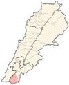
Al-Qaouzah
Al-Qaouzah
القوزح | |
|---|---|
Municipality | |
| Coordinates: 33°07′17″N 35°20′22″E / 33.12139°N 35.33944°E | |
| Grid position | 181/280 PAL |
| Country | |
| Governorate | Nabatieh Governorate |
| District | Bint Jbeil District |
| Highest elevation | 800 m (2,600 ft) |
| Lowest elevation | 700 m (2,300 ft) |
| Time zone | UTC+2 (EET) |
| • Summer (DST) | UTC+3 (EEST) |
| Dialing code | +961 |
Al-Qaouzah (also spelled Al-Qawzah, Arabic: القوزح)[1] is a municipality located in the Caza of Bint Jbeil in the Nabatiye Governorate in Lebanon.
Geography
[edit]Al-Qaouzah occupies a hill with elevation ranging from 700 to 800 meters above sea level. It is located 110 km south of Beirut.[2]
Vegetation
[edit]The main agricultural products of Al-Qaouzah are olive, carob and tobacco. Al-Qaouzah is celebrated for the quality of its thyme and za'atar production.[3]
The Saint Joseph forest stretches from the village to the border.[4]
History
[edit]Late 19th Century
[edit]In 1881, the PEF's Survey of Western Palestine (SWP) described it: "A small village, containing about 100 Christians, with a small Christian chapel situated on a hill-top, with figs, olives, and arable land; a few cisterns for the water supply.”[5]
20th Century
[edit]The Saint Joseph church was built in 1927.[6]
21st Century
[edit]In July 2006, Al-Qaouzah, like other villages that string Lebanon's southern border, such as Ain Ebel, Debel, Rmaish, and Yaroun, was caught in the 2006 Lebanon War of Hezbollah and the Israeli army.[7]
In 2019, a monkey owned by Sister Beatrice Mauger, who runs a peace project in the village, breached the border with Israel, and after a week on the loose and media frenzy, was returned to its owner by United Nations peacekeepers.[8]
Al-Qaouzah, like other villages along the border, was caught in the crossfire during the 2023 Israel–Lebanon border conflict.[9][10]
Demographics
[edit]In 2014 Christians made up 97.59% of registered voters in Al-Qaouzah. 92.03% of the voters were Maronite Catholics. The Christian population is mostly Maronite.[11]
References
[edit]- ^ ”The height or top”, according to Palmer 1881, p. 87
- ^ Germany, Yara (22 July 2022). "Qaouzah, un village qui fleure bon le thym". L'Orient Le Jour. Retrieved 28 December 2023.
- ^ Germany, Yara (22 July 2022). "Qaouzah, un village qui fleure bon le thym". L'Orient Le Jour. Retrieved 28 December 2023.
- ^ Pavec, Priscille (15 June 2018). "Au Liban-Sud, « sur un foyer de guerre, construire un foyer de paix »". L'Orient Le Jour. Retrieved 28 December 2023.
- ^ Conder and Kitchener, 1881, SWP I, p. 202
- ^ "Seize jours dans une cave pendant la guerre: le récit d'un couple libanais". La Libre. 21 July 2008. Retrieved 28 December 2023.
- ^ USATODAY.com - Archbishop tells church to stay in Lebanon: 'You'll make it'
- ^ "Tachtouch returns to Lebanon after monkeying around in Israel". The Times of Israel. AFP. 8 June 2019. Retrieved 28 December 2023.
- ^ "Hezbollah's threats to Israel harm Christian Lebanese villages analysis". The Jerusalem Post | JPost.com. 2023-10-22. Retrieved 2023-10-30.
- ^ "Israeli strike kills Lebanese soldier — Lebanese army". The Jordan Times. AFP. 6 December 2023. Retrieved 28 December 2023.
- ^ https://lub-anan.com/المحافظات/النبطية/بنت-جبيل/القوزح/المذاهب/
Bibliography
[edit]- Conder, C.R.; Kitchener, H.H. (1881). The Survey of Western Palestine: Memoirs of the Topography, Orography, Hydrography, and Archaeology. Vol. 1. London: Committee of the Palestine Exploration Fund.
- Palmer, E.H. (1881). The Survey of Western Palestine: Arabic and English Name Lists Collected During the Survey by Lieutenants Conder and Kitchener, R. E. Transliterated and Explained by E.H. Palmer. Committee of the Palestine Exploration Fund.
External links
[edit]- Survey of Western Palestine, Map 4: IAA, Wikimedia commons
- Qaouzah, Localiban


