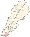
Al-Ghandouriyah
Al-Ghandouriyah
الغندوريه | |
|---|---|
Village | |
| Coordinates: 33°16′20″N 35°25′52″E / 33.27222°N 35.43111°E | |
| Grid position | 190/297 PAL |
| Country | |
| Governorate | Nabatieh Governorate |
| District | Bint Jbeil |
| Elevation | 430 m (1,410 ft) |
| Time zone | UTC+2 (EET) |
| • Summer (DST) | UTC+3 (EEST) |
Al-Ghandouriyah (Arabic: الغندوريه) is a municipality in Lebanon located in the Bint Jbeil District, south of Froun. It was formerly known as Aidib.
Name
[edit]In the 1800s, the village was called Aidib, and E. H. Palmer wrote in 1881 that the name came from a local form connected with “much sand”.[1]
History
[edit]In 1881, the PEF's Survey of Western Palestine (SWP) described Aidib as: "A small village, built of stone and mud, situated on the slope of a hill and surrounded by a few fig-trees and olives. It contains about ninety Metawileh, and is supplied with water from three rock-cut cisterns and a spring."[2]
During the 2006 Israeli offensive against Hizbollah Israeli Nahal commandos were airlifted into Al-Ghandouriyah. A column of tanks attempting to reach them was ambushed in Wadi Salouqi. Eleven tanks were hit and seventeen Israeli soldiers killed, with fifty wounded.[3]
Demographics
[edit]In 2014 Muslims made up 100% of registered voters in Al-Ghandouriyah. 96,59% of the voters were Shiite Muslims.[4]
References
[edit]- ^ Palmer, 1881, p. 13
- ^ Conder and Kitchener, 1881, SWP I, p. 202
- ^ Hirst, David (2010) Beware of Small States. Lebanon, battleground of the Middle East. Faber and Faber. ISBN 978-0-571-23741-8 pp.372-373
- ^ https://lub-anan.com/المحافظات/النبطية/بنت-جبيل/الغندوريه/المذاهب/
Bibliography
[edit]- Conder, C.R.; Kitchener, H.H. (1881). The Survey of Western Palestine: Memoirs of the Topography, Orography, Hydrography, and Archaeology. Vol. 1. London: Committee of the Palestine Exploration Fund.
- Palmer, E.H. (1881). The Survey of Western Palestine: Arabic and English Name Lists Collected During the Survey by Lieutenants Conder and Kitchener, R. E. Transliterated and Explained by E.H. Palmer. Committee of the Palestine Exploration Fund.
External links
[edit]- Ghandouriyeh, Localiban
- Survey of Western Palestine, Map 2: IAA, Wikimedia commons


