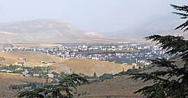
Afşin
Appearance
(Redirected from Afsin)
Afşin | |
|---|---|
District and municipality | |
 | |
 Map showing Afşin District in Kahramanmaraş Province | |
| Coordinates: 38°14′47″N 36°55′7″E / 38.24639°N 36.91861°E | |
| Country | Turkey |
| Province | Kahramanmaraş |
| Government | |
| • Mayor | Koray Kiraç (AKP) |
Area | 1,502 km2 (580 sq mi) |
| Elevation | 1,230 m (4,040 ft) |
| Population (2022)[1] | 80,044 |
| • Density | 53/km2 (140/sq mi) |
| Time zone | UTC+3 (TRT) |
| Postal code | 46500 |
| Area code | 0344 |
| Website | www |
Afşin is a municipality and district of Kahramanmaraş Province, Turkey.[2] Its area is 1,502 km2,[3] and its population is 80,044 (2022).[1] It is the location of the ancient town Arabissus.[4]
Afşin-Elbistan power stations
[edit]Two coal fired power stations are operational and are said to be damaging health via air pollution.[5]
Composition
[edit]There are 66 neighbourhoods in Afşin District:[6]
- Afşinbey
- Ağcaşar
- Alemdar
- Alimpınar
- Alpaslan
- Altaş
- Altunelma
- Anzorey
- Arıtaş
- Armutalanı
- Bakraç
- Başüstü
- Berçenek
- Beyceğiz
- Binboğa
- Büget
- Büyüksevin
- Büyüktatlı
- Çağulhan
- Çobanbeyli
- Çoğulhan
- Çomudüz
- Çukurpınar
- Dedebaba
- Deveboynu
- Dokuztay
- Efsuzturan
- Emirilyas
- Emirli
- Erçene
- Esence
- Gaziosmanpaşa
- Gerger
- Gözpınarı
- Haticepınar
- Hurman
- Hüyüklü
- İğdemlik
- İnciköy
- İncirli
- Kabaağaç
- Kale
- Kangal
- Karagöz
- Kaşanlı
- Koçovası
- Kötüre
- Küçük Tatlar
- Kuşkayası
- Marabuz
- Mehre
- Nadirköy
- Oğlakkaya
- Ördekköy
- Örenderesi
- Örenli
- Pınarbaşı
- Soğucak
- Söğütdere
- Tanır
- Topaktaş
- Türkçayırı
- Türksevin
- Yazıdere
- Yazıköy
- Yeşilyurt
References
[edit]- ^ a b "Address-based population registration system (ADNKS) results dated 31 December 2022, Favorite Reports" (XLS). TÜİK. Retrieved 19 September 2023.
- ^ Büyükşehir İlçe Belediyesi, Turkey Civil Administration Departments Inventory. Retrieved 19 September 2023.
- ^ "İl ve İlçe Yüz ölçümleri". General Directorate of Mapping. Retrieved 19 September 2023.
- ^ Lund University. Digital Atlas of the Roman Empire.
- ^ "Kahramanmaraş'ta kanserin kol gezdiği mahalle santral nedeniyle göz göre göre yok oluyor" (in Turkish). Archived from the original on 2020-10-07. Retrieved 2020-10-05.
- ^ Mahalle, Turkey Civil Administration Departments Inventory. Retrieved 19 September 2023.
External links
[edit]Wikimedia Commons has media related to Afşin.
- District governor's official website (in Turkish)
- District municipality's official website (in Turkish)


