Acorn, Arkansas
Acorn, Arkansas | |
|---|---|
| Country | United States |
| State | Arkansas |
| County | Polk |
| Elevation | 1,076 ft (328 m) |
| Population (2020) | |
• Total | 376 |
| Time zone | UTC-6 (Central (CST)) |
| • Summer (DST) | UTC-5 (CDT) |
| GNIS feature ID | 2805613[1] |
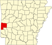
Acorn, Arkansas is an unincorporated community and census-designated place (CDP) in Polk County, Arkansas, United States, approximately 6 miles north of Mena. The town is located at the junction of U.S. Route 59, U.S. Route 71 and U.S. Route 270 in the northern part of the county. Though Acorn is only a three-way junction, it marks the end of three separate U.S. highway concurrencies: U.S. 59 & 71 from Texarkana, U.S. 59 & 270 from Heavener, Oklahoma, and U.S. 71 & 270 from "Y" City.[2]
It was first listed as a CDP in the 2020 census with a population of 376.[3]
Education
[edit]It is home to the Acorn branch of the Ouachita River School District, including Acorn Elementary School and Acorn High School.
The Ouachita River district was established by the merger of the Acorn School District and the Oden School District on July 1, 2004.[4]
Demographics
[edit]| Census | Pop. | Note | %± |
|---|---|---|---|
| 2020 | 376 | — | |
| U.S. Decennial Census[5] 2020[6] | |||
2020 census
[edit]| Race / Ethnicity (NH = Non-Hispanic) | Pop 2020[6] | % 2020 |
|---|---|---|
| White alone (NH) | 320 | 85.11% |
| Black or African American alone (NH) | 1 | 0.27% |
| Native American or Alaska Native alone (NH) | 9 | 2.39% |
| Asian alone (NH) | 0 | 0.00% |
| Pacific Islander alone (NH) | 0 | 0.00% |
| Some Other Race alone (NH) | 0 | 0.00% |
| Mixed Race or Multi-Racial (NH) | 33 | 8.78% |
| Hispanic or Latino (any race) | 13 | 3.46% |
| Total | 376 | 100.00% |
Transportation
[edit]While there is no transit service in Acorn, intercity bus service is provided by Jefferson Lines in nearby Mena.[7]
References
[edit]- ^ a b U.S. Geological Survey Geographic Names Information System: Acorn, Arkansas
- ^ Arkansas State Highway Map (Map) (2009 ed.). Arkansas State Highway and Transportation Department. § E2.
- ^ "Acorn CDP, Arkansas". United States Census Bureau. Retrieved April 15, 2022.
- ^ "ConsolidationAnnex_from_1983.xls." Arkansas Department of Education. Retrieved on May 23, 2018.
- ^ "Decennial Census of Population and Housing by Decades". US Census Bureau.
- ^ a b "P2 Hispanic or Latino, and Not Hispanic or Latino by Race – 2020: DEC Redistricting Data (PL 94-171) – Acorn CDP, Arkansas". United States Census Bureau.
- ^ "Arkansas Bus Stops". Retrieved September 28, 2023.
External links
[edit]34°38′34″N 94°12′04″W / 34.64278°N 94.20111°W

