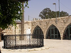
Abraham's Well
 | |
 | |
| Location | 2 Hebron Road, Beersheba |
|---|---|
| Coordinates | 31°14′14.01″N 34°47′35.08″E / 31.2372250°N 34.7930778°E |
| Type | history |
| Website | abraham.org.il |
Abraham's Well (Hebrew: באר אברהם) is a historical water well in Beersheba, Israel, associated with the biblical narrative of Abraham. Its structure houses the archaeology museum of Beersheba.
History
[edit]
According to the Hebrew Bible, Abraham's well was seized by Abimelech's men (Genesis 21:25), and Isaac’s servants also dug a well at Beersheba (Genesis 26:25).
The well is near the Old City of Beersheba and a wadi, Nahal Be'er Sheva, on the road to Neve Noy. It was described by Edward Robinson in 1838.[1] In 1897, a local sheikh built a house above the well.
Travellers' descriptions
[edit]Edward Robinson's description of the site:[2] "These wells are some distance apart; they are circular, and stoned up with solid masonry. The larger one is twelve and a half feet in diameter and forty-four and a half feet deep to the surface of the water, sixteen feet of which, at the bottom, is excavated in the solid rock. The other well lies fifty-five rods W.S.W., and is five feet in diameter and forty-two feet deep. The water in both is pure and sweet, and in great abundance; the finest, indeed, we had found since leaving Sinai... Here then is the place where the patriarchs Abraham, Isaac, and Jacob often dwelt! Here Abraham dug perhaps this very well; and journeyed from hence with Isaac to Mount Moriah, to offer him up there in sacrifice."
It was also described by Claude Reignier Conder in the late 19th century:[3] "...the principal well, which is twelve feet three inches in diameter, and over forty-five feet deep, lined with rings of masonry to a depth of twenty-eight feet. A second well, five feet in diameter, exists about 300 yards to the west, and on the east is a third, which is dry, twenty-three feet deep, and nine feet two inches in diameter. The sides of all the wells are furrowed by the ropes of the water-drawers; but we made one discovery which was rather disappointing, namely, that the masonry is not very ancient. Fifteen courses down, on the south side of the large well, there is a stone with an inscription in Arabic, on a tablet dated, as well as I could make out, 505 A.H., or in the twelfth century. This stone must be at least as old as those at the mouth, which are furrowed with more than a hundred channels by the ropes of seven centuries of water-drawers."
See also
[edit]References
[edit]- ^ Jerusalem Post, TODAY IN HISTORY: THE ‘FATHER OF BIBLICAL GEOGRAPHY’; BENJAMIN GLATT; January 27, 2016
- ^ "Biblical researches in Palestine, Mount Sinai and Arabia Petraea. A journal of travels in the year 1838". archive.org. Retrieved 2017-08-29.
- ^ "Tent work in Palestine : a record of discovery and adventure". archive.org. 1879. Retrieved 2017-08-29.

