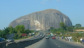
A2 highway (Nigeria)
| Trunk Road A2 | ||||
|---|---|---|---|---|
 | ||||
| Route information | ||||
| Maintained by Federal Ministry of Power, Works and Housing | ||||
| Major junctions | ||||
| South end | ||||
| North end | – Niger | |||
| Location | ||||
| Country | Nigeria | |||
| Major cities | ||||
| Highway system | ||||
| ||||
The A2 highway is a federal highway in Nigeria that spans 1,200 kilometres (750 mi). It serves as a vital transportation route, connecting the country's southern and northern regions.[1]
Route description
[edit]The A2 begins in the bustling city of Port Harcourt, located in Rivers State, and heads westward, passing through Elele in the same state. It then proceeds to the city of Warri in Delta State before reaching Benin City in Edo State.[2]
From Benin City, the A2 turns northward, leading to Ekpoma, another town in Edo State, and further on to Okene, situated in Kogi State. Continuing north, the highway enters the Federal Capital Territory, connecting Nigeria's capital city, Abuja.[3]
The A2 then heads northward, passing through Kaduna and Zaria in Kaduna State. Further north, it reaches the metropolis of Kano, providing a transportation link for the region.[4]
Beyond Kano, the A2 continues its journey northward, reaching Kazaure in Jigawa State before culminating at Daura in Katsina State. Finally, the highway reaches its northernmost point at the border with Niger.
Connectivity
[edit]The A2 highway is a prominent component of Nigeria's road network, serving as a key link between the southern and northern states. It facilitates the transportation of goods and people, supporting economic activities and regional integration.[5]
Additionally, the A2 forms a part of the Trans-Saharan highway system, contributing to international connectivity.[6] This system establishes connections between Nigeria and Algeria, as well as the broader North African region, promoting trade and cultural exchange.[7]
The A2 spans across seven states: Rivers, Delta, Edo, Kogi, Federal Capital Territory, Kaduna, and Katsina. It also plays a vital role in connecting Nigeria's capital, Abuja, with the remainder of the country.[8]
References
[edit]- ^ "Where Roads are the enemy" (PDF). www.sbmintel.com. 2017. p. 4. Retrieved September 2, 2023.
- ^ "Where roads are the enemy – A look at the state of Nigeria's roads". Nigeria's leading geopolitical intelligence platform. 2017-10-12. Retrieved 2023-09-02.
- ^ Olojede, Olorunfemi A; Agbola, Samuel B; Samuel, Kayode J (July 2019). "Residents' assessment of local government road infrastructure delivery in Ile-Ife, Nigeria". Local Economy: The Journal of the Local Economy Policy Unit. 34 (4): 346–363. doi:10.1177/0269094219857044. ISSN 0269-0942.
- ^ "Rethinking Roads in Nigeria". www.stears.co. Retrieved 2023-09-02.
- ^ "ROAD MAINTENANCE: 4 Critical Functions of Road Maintenance in Nigeria". Sapient Vendors. 2016-10-20. Retrieved 2023-09-02.
- ^ "The Trans-Saharan Road Liaison Committee TRLC" (PDF). Study of Identification of Potential Trade Between the Member Countries of the Trans-Saharan Road Liaison Committee. 2009.
- ^ "Trans Sahara Routes". Sahara Overland. 2013-09-07. Retrieved 2023-09-02.
- ^ "Concerns over deplorable Nigerian roads (III) - Daily Trust". dailytrust.com. Retrieved 2023-09-02.


