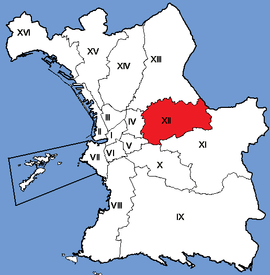
12th arrondissement of Marseille
Appearance
12th arrondissement of Marseille | |
|---|---|
 Location within Marseille | |
| Coordinates: 43°18′26″N 5°25′31″E / 43.307185°N 5.425376°E | |
| Country | France |
| Region | Provence-Alpes-Côte d'Azur |
| Department | Bouches-du-Rhône |
| Commune | Marseille |
| Government | |
| • Mayor (2020–2026) | Sylvain Souvestre (LR) |
Area | 14.00 km2 (5.41 sq mi) |
| Population (2021)[1] | 63,108 |
| • Density | 4,508/km2 (11,680/sq mi) |
| INSEE code | 13212 |
The 12th arrondissement of Marseille (French: 12e arrondissement de Marseille, "douzième", [duzjɛm‿aʁɔ̃dismɑ̃ də maʁsɛj]), commonly known as Marseille 12, is one of the 16 arrondissements of Marseille. It is governed locally together with the 11th arrondissement, with which it forms the 6th sector of Marseille.
Population
[edit]| Neighbourhood | population 1990 | population 1999 | population 2006 |
|---|---|---|---|
| Les Caillols | 8 480 | 8 881 | 8 606 |
| La Fourragère | 7 199 | 7 277 | 7 172 |
| Montolivet | 11 769 | 11 477 | 12 199 |
| Saint-Barnabé | 12 158 | 12 187 | 12 507 |
| Saint-Jean du Désert | 3 151 | 2 920 | 2 798 |
| Saint-Julien | 9 429 | 9 552 | 9 820 |
| Les Trois-Lucs | 3 669 | 4 110 | 4 806 |
| Total | 55 855 | 56 404 | 57 908 |
References
[edit]- ^ "Populations légales 2021" (in French). The National Institute of Statistics and Economic Studies. 28 December 2023.
External links
[edit]- Official website Archived 2021-03-05 at the Wayback Machine
- Dossier complet, INSEE
