Šampēteris
Appearance
Šampēteris | |
|---|---|
Neighbourhood of Riga | |
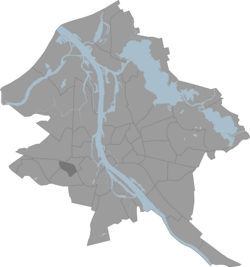
 Location of Šampēteris in Riga | |
| Country | Latvia |
| City | Riga |
| District | Zemgale Suburb |
| Area | |
| • Total | 1.366 km2 (0.527 sq mi) |
| Population (2018) | |
| • Total | 4,886 |
| • Density | 3,600/km2 (9,300/sq mi) |
| Website | apkaimes.lv |
Šampēteris is an old Riga neighbourhood on the Pārdaugava side of the Daugava river, with many houses built in the first part of 20th century still surviving.
Etymology
[edit]The area's name comes from the French word champêtre, which means 'rural, pastoral'.
56°56′31″N 24°02′23″E / 56.9419°N 24.0397°E
