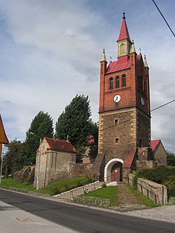
Łagiewniki, Lower Silesian Voivodeship
Appearance
Łagiewniki | |
|---|---|
Village | |
 Bell tower of the Church of Saint Joseph | |
| Coordinates: 50°47′28″N 16°50′39″E / 50.79111°N 16.84417°E | |
| Country | |
| Voivodeship | Lower Silesian |
| County | Dzierżoniów |
| Gmina | Łagiewniki |
| Population | |
• Total | 2,900 |
| Time zone | UTC+1 (CET) |
| • Summer (DST) | UTC+2 (CEST) |
| Vehicle registration | DDZ |
| National roads | |
| Voivodeship road | |
| Website | http://www.lagiewniki.pl/ |
Łagiewniki [waɡʲɛvˈɲikʲi] is a village in Dzierżoniów County, Lower Silesian Voivodeship, in south-western Poland.[1] It is the seat of the administrative district (gmina) called Gmina Łagiewniki.
It lies approximately 23 kilometres (14 mi) east of Dzierżoniów and 40 km (25 mi) south of the regional capital Wrocław.
History
[edit]In the final stages of World War II, on 25 January 1945, a German-organized death march of Allied prisoners of war from the Stalag Luft 7 POW camp passed through the village.[2]
From 1975 to 1998 the village was in Wrocław Voivodeship.
References
[edit]- ^ "Central Statistical Office (GUS) - TERYT (National Register of Territorial Land Apportionment Journal)" (in Polish). 2008-06-01.
- ^ Stanek, Piotr (2015). "Stalag Luft 7 Bankau i jego ewakuacja na Zachód w styczniu 1945 r.". Łambinowicki rocznik muzealny (in Polish). 38. Opole: 66. ISSN 0137-5199.

