Česká Kamenice
Česká Kamenice | |
|---|---|
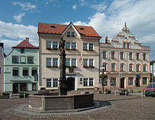
 Míru Square, historic centre | |
| Coordinates: 50°47′52″N 14°25′4″E / 50.79778°N 14.41778°E | |
| Country | |
| Region | Ústí nad Labem |
| District | Děčín |
| First mentioned | 1352 |
| Government | |
| • Mayor | Jan Papajanovský |
| Area | |
| • Total | 38.77 km2 (14.97 sq mi) |
| Elevation | 301 m (988 ft) |
| Population (2024-01-01)[1] | |
| • Total | 5,082 |
| • Density | 130/km2 (340/sq mi) |
| Time zone | UTC+1 (CET) |
| • Summer (DST) | UTC+2 (CEST) |
| Postal code | 407 21 |
| Website | www |
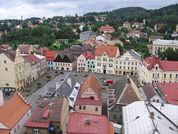
Česká Kamenice (Czech pronunciation: [ˈtʃɛskaː ˈkamɛɲɪtsɛ]; German: Böhmisch Kamnitz) is a town in Ústí nad Labem Region of the Czech Republic. It has about 5,100 inhabitants. The historic town centre is well preserved and is protected by law as an urban monument zone.
Administrative parts
[edit]The villages of Dolní Kamenice, Filipov, Horní Kamenice, Huníkov, Kamenická Nová Víska, Kerhartice, Líska, Pekelský Důl and Víska pod Lesy are administrative parts of Česká Kamenice.
Etymology
[edit]The name Kamenice was transferred to the settlement from the Kamenice River. In the 14th century, the settlement was called Německá Kamenice ("German Kamenice") to distinguish it from nearby Srbská Kamenice. From the 17th century, the name Česká Kamenice ("Bohemian Kamenice") is used.[2]
Geography
[edit]
Česká Kamenice is located about 13 kilometres (8 mi) east of Děčín. The municipal territory is hilly and extends into three geomorphological regions: Lusatian Mountains, Central Bohemian Uplands and Elbe Sandstone Mountains. The highest point is the Studenec hill at 737 m (2,418 ft) above sea level.
The Kamenice River and several brooks flow through Česká Kamenice.
History
[edit]The first written mention of Česká Kamenice is from 1352. The town was founded at the crossroads of two paths, the so-called "Bohemian Road" and the "Lusatian Road", probably in the area of an older Slavic settlement. It was founded before 1283, probably in the 1270s during the reign of King Ottokar II, when the colonization of the region culminates mainly in settlers from neighbouring Saxony.[3]
Concentration camp
[edit]In spring 1944, the Rabstein sub-camp of Flossenbürg concentration camp was created here, with a capacity of 600 prisoners. At the end of the war, 1,500 inmates were incarcerated in the camp. The camp provided workers for the nearby underground aircraft factory in the town of Janská, 3 km west of Česká Kamenice. The number of inmate deaths is not known due to the destruction of all camp documentation. The foundations of the camp buildings remain visible, along with a memorial and historical overview.[4]
Demographics
[edit]
|
|
| ||||||||||||||||||||||||||||||||||||||||||||||||||||||
| Source: Censuses[5][6] | ||||||||||||||||||||||||||||||||||||||||||||||||||||||||
Transport
[edit]
The I/13 road (the section from Liberec to Děčín, part of the European route E442) passes through the town.
Česká Kamenice is located on the railway line Děčín–Rumburk.[7] Česká Kamenice is also connected with Kamenický Šenov by a short railway line. Historic trains run on it. It is only in operation during the summer tourist season and on weekends in some months out of season.[8]
Sights
[edit]
Míru Square and its surroundings form the historic town centre. The stone renaissance fountain on the square is from 1574. The main landmarks of the centre are Church of Saint James the Great, Evangelical church, Pilgrimage Chapel of the Nativity of the Virgin Mary, Kamenice Chateau and Salhausen Chateau. There are many preserved houses in Neoclassical and Art Nouveau styles.[9]
Due to the natural conditions, there are several rocky lookouts in the area. On Studenec, there is an iron observation tower from 1888, a technical monument. A ruin of Česká Kamenice Castle is preserved on the Zámecký hill, in its premises there is a wooden observation tower.[10]
The remains of the concentration camp and the underground aircraft factory contains an exposition and under certain conditions are open to the public.[10]
Notable people
[edit]- Joseph Rothe (1759–1808), Austrian operatic singer
- Johann Baptist Emanuel Pohl (1782–1834), Austrian botanist, entomologist, geologist and physician
- Antonín Dvořák (1841–1904), composer; took organ and music-theory lessons here in 1856
- Hannes Hegen (1925–2014), German illustrator and caricaturist
- Sigurd Hofmann (1944–2022), German physicist
Twin towns – sister cities
[edit]Česká Kamenice is twinned with:[11]
 Bad Schandau, Germany
Gallery
[edit]-
Chapel of the Nativity of the Virgin Mary
-
Salhausen Chateau
-
Kamenice Castle
-
Rabštejn underground factory
-
Observation tower on Studenec
References
[edit]- ^ "Population of Municipalities – 1 January 2024". Czech Statistical Office. 2024-05-17.
- ^ Profous, Antonín (1949). Místní jména v Čechách II: CH–L (in Czech). p. 194.
- ^ "Historie města" (in Czech). Město Česká Kamenice. Retrieved 2021-07-15.
- ^ "Museum of concentration camp of underground airfactory in Rabstejn". Archived from the original on 2005-07-28.
- ^ "Historický lexikon obcí České republiky 1869–2011" (in Czech). Czech Statistical Office. 2015-12-21.
- ^ "Population Census 2021: Population by sex". Public Database. Czech Statistical Office. 2021-03-27.
- ^ "Detail stanice Česká Kamenice" (in Czech). České dráhy. Retrieved 2024-07-10.
- ^ "Kamenický motoráček" (in Czech). Klub železničních cestovatelů. Retrieved 2024-07-10.
- ^ "Městská památková zóna Česká Kamenice" (in Czech). Město Česká Kamenice. Retrieved 2021-07-15.
- ^ a b "Kulturní památky, Turistické cíle" (in Czech). Město Česká Kamenice. Retrieved 2021-07-15.
- ^ "Partner Towns". Město Česká Kamenice. Retrieved 2023-01-15.
External links
[edit]- Official website (in Czech)
- Microregion Českokamenicko (in Czech)
- Historical postcards of Česká Kamenice
- Virtual show


