Écouché-les-Vallées
Écouché-les-Vallées | |
|---|---|
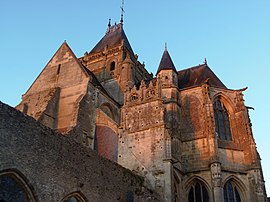
 The church in Écouché | |
| Coordinates: 48°43′05″N 0°07′30″W / 48.718°N 0.125°W | |
| Country | France |
| Region | Normandy |
| Department | Orne |
| Arrondissement | Argentan |
| Canton | Magny-le-Désert |
| Intercommunality | Argentan Intercom |
| Government | |
| • Mayor (2020–2026) | Alain Lolivier[1] |
| Area 1 | 41.23 km2 (15.92 sq mi) |
| Population (2021)[2] | 2,197 |
| • Density | 53/km2 (140/sq mi) |
| Time zone | UTC+01:00 (CET) |
| • Summer (DST) | UTC+02:00 (CEST) |
| INSEE/Postal code | 61153 /61150 |
| 1 French Land Register data, which excludes lakes, ponds, glaciers > 1 km2 (0.386 sq mi or 247 acres) and river estuaries. | |
Écouché-les-Vallées (French pronunciation: [ekuʃe le vale]) is a commune in the department of Orne, northwestern France. The municipality was established on 1 January 2016 by merger of the former communes of Batilly, La Courbe, Écouché (the seat), Loucé, Saint-Ouen-sur-Maire and Serans.[3] On 1 January 2018, the former commune of Fontenai-sur-Orne was merged into Écouché-les-Vallées.[4] It's seat, Écouché, is classed as a Petites Cités de Caractère.[5]
Geography
[edit]The commune is made up of the following collection of villages and hamlets: La Courbe, Mesnil-Glaise, Le Haut du Château, Batilly, Treize Saints, L'Être Hubert, Saint-Ouen-sur-Maire, Serans, Écouché, Méheudin, Loucé, Noiseville, Le Hamel and Fontenai-sur-Orne.
The parts of the commune that contains Batilly and La Courbe is part of the area known as Suisse Normande.[6]
Écouché-les-Vallées along with another 69 communes is part of a 20,593 hectare, Natura 2000 conservation area, called the Haute vallée de l'Orne et affluents.[7]
The Commune has 5 rivers running through it with another 6 streams. The five rivers are the Orne, Maire, Baize, Cance and Udon.[8] The 6 streams are the Chalau, Commune, Barbottiere, Vloger and Aunais.
Population
[edit]| Year | Pop. | ±% p.a. |
|---|---|---|
| 1968 | 2,218 | — |
| 1975 | 2,245 | +0.17% |
| 1982 | 2,291 | +0.29% |
| 1990 | 2,298 | +0.04% |
| 1999 | 2,284 | −0.07% |
| 2007 | 2,303 | +0.10% |
| 2012 | 2,218 | −0.75% |
| 2017 | 2,169 | −0.45% |
| Source: INSEE[9] | ||
Notable buildings and places
[edit]- Parc de Sculptures de l'Atelier Balias is a 4 Hectare garden that is open to the public. It features over 55 statues today and was created in 1825.[10][11]
- Gardens of Méheudin. is a 2 ha garden and Arboretum in Écouché.[12] The Garden was started in 1978 and features over 300 types of trees and ornamental shrubs.[13]
National heritage sites
[edit]The Commune has 5 buildings and areas listed as a Monument historique.
- Lower grounds of la Courbe a barred spur from a Protohistory site.[14]
- Upper Castle grounds a Protohistory site that still has remains of the ditches and embankments used for the castle.[15]
- la Queurie Lodge a 15th century manor in La Courbe.[16]
- Notre Dame Church a 13th century church in Ecouché.[17]
- Loucé Church a 12th century church in Loucé.[18]
Notable People
[edit]- André Chéradame French journalist and scholar from the École Libre des Sciences Politiques born in 1871 in Ecouches.[19]
Twin town
[edit]Transport
[edit]The commune has a Railway station in Écouché, that was opened in 1866 and serves part of the Argentan to Granville line.[21]
See also
[edit]References
[edit]- ^ "Répertoire national des élus: les maires" (in French). data.gouv.fr, Plateforme ouverte des données publiques françaises. 13 September 2022.
- ^ "Populations légales 2021" (in French). The National Institute of Statistics and Economic Studies. 28 December 2023.
- ^ Arrêté préfectoral 26 October 2015 (in French)
- ^ Arrêté préfectoral 15 December 2017 (in French)
- ^ HOUDOU, Gérard (17 July 2023). "Connaissez-vous les Petites Cités de Caractère de l'Orne ?". Ouest-France.fr.
- ^ "Map of Suisse Normande" (PDF).
- ^ "INPN - FSD Natura 2000 - FR2500099 - Haute vallée de l'Orne et affluents - Description".
- ^ Sandre. "Fiche cours d'eau - L'Orne (I2--0200)".
- ^ Population en historique depuis 1968, INSEE
- ^ "Parc de Sculptures de l'Atelier Balias à Ecouché (61)". www.jardinez.com.
- ^ "À 19 ans, il porte sur ses épaules l'atelier Balias". Ouest-France.fr. 26 April 2016.
- ^ "Les jardins vous ouvrent leurs portes". Ouest-France.fr. 31 May 2013.
- ^ "PARC ET JARDINS DE MÉHEUDIN - Comité des Parcs et Jardins de France". www.parcsetjardins.fr.
- ^ "Camp du Bas de la Courbe (éperon barré) à La Courbe - PA00110783". monumentum.fr.
- ^ "Camp du Haut du Château à La Courbe - PA00110784". monumentum.fr.
- ^ "Logis de la Queurie à La Courbe - PA00110785". monumentum.fr.
- ^ "Eglise Notre-Dame à Ecouché - PA00110798". monumentum.fr.
- ^ "Eglise à Loucé - PA00110983". monumentum.fr.
- ^ Nicolas Ginsburger. "ANDRÉ CHÉRADAME ET L'ÉMERGENCE D'UNE CARTOGRAPHIE GÉOPOLITIQUE DE GUERRE EN 1916" (PDF). lecfc.fr.
- ^ "Jumelage - Commune d'Écouché-les-Vallées - Site officiel". www.ecouchelesvallees.fr.
- ^ "Toutes les infos de la gare SNCF Écouché". Infos Gare.
- ^ "Écouché-les-Vallées · France". Écouché-les-Vallées · France.


